 Filter: Categories of Wisconsin Historical Images
Filter: Subject of Roads
Filter: County of Dunn
Filter: Categories of Wisconsin Historical Images
Filter: Subject of Roads
Filter: County of Dunn
| Date: | 1920 |
|---|---|
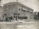
| Description: | Brick building containing the Olaf Noer Drugstore. A man (presumably Mr. Noer himself) poses in the doorway. |

| Date: | 1897 |
|---|---|
| Description: | View down dirt road, with a few homes on each side of the lane. |
| Date: | 1897 |
|---|---|
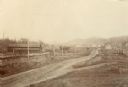
| Description: | Road lined with fences leading into town. Several houses are visible in the distance. A railroad track and electric or telegraph line runs along the left s... |
| Date: | 1880 |
|---|---|
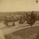
| Description: | The view of Red Cedar River from Meadow Hill. |
| Date: | 1900 |
|---|---|
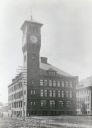
| Description: | The Stout State College Industrial Arts Building, rebuilt after a fire destroyed the original building in 1897. A clock tower is at the front left corner o... |
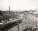
| Date: | 1899 |
|---|---|
| Description: | Elevated view looking north towards Menomonie, the Knapp, Stout and Company lumber mills. |
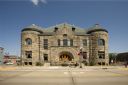
| Date: | 2009 |
|---|---|
| Description: | Exterior view of Mabel Tainter Memorial Theater from accross the street. |
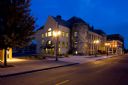
| Date: | 2009 |
|---|---|
| Description: | View of Mabel Tainter Memorial Theater from across street including 2007 annex. |
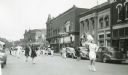
| Date: | 1942 |
|---|---|
| Description: | A high school band marches down a street during MacArthur Week, a state sponsored scrap drive effort. |

| Date: | |
|---|---|
| Description: | View from intersection toward the facade and right side of the post office. The building consists of brick with stone accents on the top of the arched fron... |

| Date: | |
|---|---|
| Description: | View across street toward the Congregational Church, which features a large stained glass window on the left side of the structure. The building is brick w... |

| Date: | 1930 |
|---|---|
| Description: | View down unpaved road lined with trees toward an automobile driving up the lane toward a fence. |
| Date: | 1927 |
|---|---|
| Description: | Shows section corners, landownership and acreages, roads, railroad, Weston village, and buildings of W.J. Starr Estate. Relief shown by hachures. "Map comp... |

| Date: | 1970 |
|---|---|
| Description: | This pictorial map of Dunn County, Wisconsin, from the 1970s depicts historical events that occurred in the county. It shows cemeteries, churches, schools,... |

| Date: | 1911 |
|---|---|
| Description: | This map shows plat of town, local streets, numbered lots, blocks, and wards, roads, Lake Menomin, Wilson Creek, Red Cedar River, and land ownership by nam... |

| Date: | 1877 |
|---|---|
| Description: | This map is a photstat copy of the original and shows landownership, townships and sections, wagon roads, railroads, school houses, churches, cemeteries, m... |

| Date: | 1907 |
|---|---|
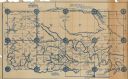
| Description: | This blueprint map shows a proposed plan for pleasure roads and reservation system. It also shows schools, cemeteries, old river channel, proposed bridge, ... |

| Date: | 1973 |
|---|---|
| Description: | View looking up road on a hill towards trees with fall colors of yellow, orange and red leaves. |

| Date: | |
|---|---|
| Description: | View of a highway bridge spanning the Red Cedar River, and a road along the far shoreline. Caption reads: "U.S. Hy 12 New Bridge, Menomonie, Wis." |
If you didn't find the material you searched for, our Library Reference Staff can help.
Call our reference desk at 608-264-6535 or email us at: