 Filter: Categories of Wisconsin Historical Images
Filter: Subject of Roads
Filter: County of Douglas
Filter: Categories of Wisconsin Historical Images
Filter: Subject of Roads
Filter: County of Douglas
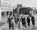
| Date: | 1943 |
|---|---|
| Description: | Elvated view of war hero Richard Ira Bong (center, in flight jacket) on leave in Poplar, with friends, relatives, and admirers. The group is walking down a... |

| Date: | 1883 |
|---|---|
| Description: | Bird's-eye map of Superior, county seat of Douglas County, on the shores of Lake Superior, with insets of points of interest. |

| Date: | 1913 |
|---|---|
| Description: | Bird's-eye map of Superior. "The New Steel Center." |

| Date: | 1915 |
|---|---|
| Description: | Bird's-eye view of Superior, Wisconsin, and Duluth, Minnesota on opposite shore of Lake Superior. |
| Date: | 1920 |
|---|---|
| Description: | View of Tower Avenue at 13th Street. A furniture store and a hotel are along the left side of the street. Caption reads: "Tower Avenue at 13th Street, Supe... |

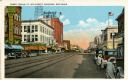
| Date: | 1900 |
|---|---|
| Description: | Elevated view of Tower Avenue. Caption reads: "Tower Avenue, Superior, Wis." |
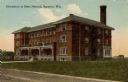
| Date: | 1910 |
|---|---|
| Description: | View from road toward the dormitory. Caption reads: "Dormitory at State Normal, Superior, Wis." |
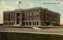
| Date: | 1930 |
|---|---|
| Description: | Exterior view across street towards a high school. Caption reads: "High School, Superior, Wis." |
| Date: | 1930 |
|---|---|
| Description: | View of the Davidson Feed Mill near the Amnicon River. |
| Date: | 1919 |
|---|---|
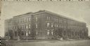
| Description: | Panoramic view of county buildings located at West 5th and Newton Avenues. |
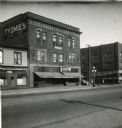
| Date: | 08 1947 |
|---|---|
| Description: | Exterior view of the Tyomies Publishing Company building. The 6th Street Cafe is next door on the left. |
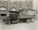
| Date: | 1919 |
|---|---|
| Description: | A man sits in an International model "G" truck that has wood furniture and crates filling the bed. The building behind has signs advertising for a laundry. |
| Date: | 1890 |
|---|---|
| Description: | Exterior view from across street of Roosevelt Terrace apartments. |
| Date: | 1935 |
|---|---|
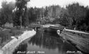
| Description: | Elevated view of the Brule River in northern Wisconsin, flowing between a road and landscaped stone wall under a bridge and pedestrian walkway. |

| Date: | 1889 |
|---|---|
| Description: | This 1889 map of Douglas County, Wisconsin, shows the township and range grid, towns, sections, cities and villages, roads, existing and proposed railroads... |

| Date: | 1892 |
|---|---|
| Description: | This 1892 map of Douglas County, Wisconsin, shows the township and range grid, towns, sections, cities and villages, roads, railroads, trails, lakes and st... |

| Date: | 1899 |
|---|---|
| Description: | This 1899 map of Douglas County, Wisconsin, shows the township and range grid, towns, sections, cities, villages and railroad stations, mines, roads, railr... |

| Date: | 1911 |
|---|---|
| Description: | This map, taken from the 1911 Map of Wisconsin showing geology and roads by Hotchkiss and Thwaites, shows the northwest portion of Douglas County, Wisconsi... |

| Date: | 1914 |
|---|---|
| Description: | This 1914 map of Douglas County, Wisconsin, shows the township and range grid, towns, sections, cities and villages, roads, railroads, Indian trails, schoo... |

| Date: | 1953 |
|---|---|
| Description: | This is a detailed map of Douglas County, Wisconsin, showing townships and township borders, numbered wards, roadways, and bodies of water. There are annot... |
If you didn't find the material you searched for, our Library Reference Staff can help.
Call our reference desk at 608-264-6535 or email us at: