 Filter: Categories of Wisconsin Historical Images
Filter: Subject of Roads
Filter: County of Dodge
Filter: Year of 1800-1899
Filter: Categories of Wisconsin Historical Images
Filter: Subject of Roads
Filter: County of Dodge
Filter: Year of 1800-1899

| Date: | 1867 |
|---|---|
| Description: | Birds-eye drawing of Beaver Dam, Dodge Co., depicting street names and street layout, houses, rivers, lakes, and trees. A reference key at the bottom of th... |

| Date: | 1892 |
|---|---|
| Description: | This bird's-eye view map is oriented looking north-east and includes index of points of interest and businesses. The map is a photocopy. |

| Date: | 1885 |
|---|---|
| Description: | Bird's-eye map of Hustisford. |

| Date: | 1896 |
|---|---|
| Description: | This late 19th-century map of Dodge County, Wisconsin, shows the township and range grid, towns, sections, cities, villages and post offices, some property... |

| Date: | 1899 |
|---|---|
| Description: | This 1899 map of Dodge County, Wisconsin, shows the township and range grid, towns, sections, cities and villages, roads, railroads, post offices, cemeteri... |

| Date: | 1852 |
|---|---|
| Description: | Map created between 1852 and 1867 shows numbered lots, labelled roads, the "Centre Line of LaCrosse & Milwaukee R.R." railroad, and a station house. Roads ... |

| Date: | 1870 |
|---|---|
| Description: | This map is ink and color on tracing cloth and shows Iron Ridge, the hotel and saw mill at Iron Ridge Village, Milwaukee & St. Paul Railway, plank road, an... |
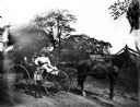
| Date: | 1899 |
|---|---|
| Description: | Sarah Krueger and five Hable children riding a horse-drawn buggy down a road. Sarah is holding the reins. |
If you didn't find the material you searched for, our Library Reference Staff can help.
Call our reference desk at 608-264-6535 or email us at:
