 Filter: Categories of Wisconsin Historical Images
Filter: Subject of Roads
Filter: County of Dodge
Filter: Categories of Wisconsin Historical Images
Filter: Subject of Roads
Filter: County of Dodge
| Date: | 10 1996 |
|---|---|
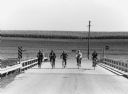
| Description: | "Bike riders cross the Rock River near the intersection of AY & Gill Road." |
| Date: | 03 17 1997 |
|---|---|
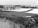
| Description: | "The camera faces northeast from the water tower site." |

| Date: | 1997 |
|---|---|
| Description: | "Looking southeast of the water tower are Carl Benter rental units." |
| Date: | 05 26 1997 |
|---|---|
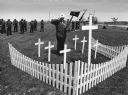
| Description: | "Theresa American Legion Post 270 veterans visited seven cemeteries as they paid homage to departed comrades. Gary Erdman, Sargent-at-arms, stood at attent... |

| Date: | 1896 |
|---|---|
| Description: | This late 19th-century map of Dodge County, Wisconsin, shows the township and range grid, towns, sections, cities, villages and post offices, some property... |

| Date: | 1930 |
|---|---|
| Description: | This manuscript map, likely drawn in the 1930s, shows Fox Lake, in Dodge County, Wisconsin, and the roads and resorts in the vicinity. |

| Date: | 1899 |
|---|---|
| Description: | This 1899 map of Dodge County, Wisconsin, shows the township and range grid, towns, sections, cities and villages, roads, railroads, post offices, cemeteri... |

| Date: | 1852 |
|---|---|
| Description: | Map created between 1852 and 1867 shows numbered lots, labelled roads, the "Centre Line of LaCrosse & Milwaukee R.R." railroad, and a station house. Roads ... |
| Date: | 1909 |
|---|---|
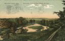
| Description: | Colorized postcard of an elevated view of a river with a dam in the distance. Caption reads: "Beaver Dam, Wis. Birds-eye View of River Below the Dam." |

| Date: | 09 1957 |
|---|---|
| Description: | The Zastrow wedding party is shown on their way to the Mayville Park Pavilion. Locals will recognize this hill on the Mayville Road before it was leveled o... |

| Date: | 1932 |
|---|---|
| Description: | This map of Beaver Dam shows new boundary lines for wards, existing wards, roads, railroads, and rivers. Roads and Beaver Dam Lake are labeled. There are s... |

| Date: | 1952 |
|---|---|
| Description: | This map of Beaver Dam shows state trunk highway system, county trunk highway system, town roads, rivers, and Beaver Dam Lake and includes an additional at... |
| Date: | 04 1987 |
|---|---|
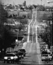
| Description: | A 500 mm telephoto lens compressed Cty Trunk Y as it meanders from Kekoskee in the foremground north towards Leroy. A funeral cortage passes in the foregro... |

| Date: | 10 1996 |
|---|---|
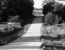
| Description: | Chelsey and Logan Wilz explore McArthur Road. |
| Date: | 08 1996 |
|---|---|
| Description: | Shirley Widmer biking on McArthur Road. |
| Date: | 09 2000 |
|---|---|
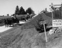
| Description: | Wagon Train organized by Everett Schultz family living on Pole Road. |

| Date: | 09 2000 |
|---|---|
| Description: | Wagon Train continues on McArther Road. |

| Date: | 03 1978 |
|---|---|
| Description: | The Lomira Girls Basketball Team is on their way to the WIAA State Tournament in Madison. |

| Date: | 1870 |
|---|---|
| Description: | This map is ink and color on tracing cloth and shows Iron Ridge, the hotel and saw mill at Iron Ridge Village, Milwaukee & St. Paul Railway, plank road, an... |
If you didn't find the material you searched for, our Library Reference Staff can help.
Call our reference desk at 608-264-6535 or email us at:
