 Filter: Categories of Wisconsin Historical Images
Filter: Subject of Roads
Filter: County of Dane
Filter: Year of 1900-1999
Filter: Year of 1950-1959
Filter: Categories of Wisconsin Historical Images
Filter: Subject of Roads
Filter: County of Dane
Filter: Year of 1900-1999
Filter: Year of 1950-1959

| Date: | 1956 |
|---|---|
| Description: | Aerial view of the South Park Street interchange. |
| Date: | 1954 |
|---|---|
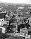
| Description: | Elevated view of State Street looking toward Bascom Hall and the University of Wisconsin-Madison campus from the Wisconsin State Capitol dome. |

| Date: | 06 07 1954 |
|---|---|
| Description: | Aerial view of the Midvale neighborhood under construction showing the intersection of Midvale and Tokay Boulevards near the southwestern city limits of Ma... |

| Date: | 06 07 1954 |
|---|---|
| Description: | Aerial view looking north from near the city's southwestern limits in 1954. Shows text indicating Midvale Boulevard, Odana Road, Tokay Boulevard, Mineral P... |

| Date: | 1955 |
|---|---|
| Description: | Aerial view of Midvale neighborhood under construction near Madison's southwestern city limits. The view is focused on the area bounded by Tokay Boulevard,... |
| Date: | 1958 |
|---|---|
| Description: | 2700 Marshall Court, Doctor's Park, Shorewood Hills. |

| Date: | 1958 |
|---|---|
| Description: | Aerial view of Craig Avenue and Crestwood Avenue. |

| Date: | 1955 |
|---|---|
| Description: | Air view of University Avenue at Midvale Boulevard. |

| Date: | 03 14 1955 |
|---|---|
| Description: | Exterior of Tommy's Conoco Oil Station, 3116 East Washington Avenue at Commercial Avenue (aka Highway 30). Includes gas pumps, one automobile, and a Tommy'... |

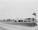
| Date: | 09 05 1954 |
|---|---|
| Description: | Harp & Kettle Cheese House drive-in restaurant and store, 310 E. Broadway, includes two cars in the parking lot. |

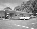
| Date: | 06 16 1955 |
|---|---|
| Description: | Robert Blossom's Mobil gas station, 3702 East Washington Avenue. Background includes Mayfair Homes sign and Jacob's Mobile Home Sales, 3715 East Washingto... |
| Date: | 06 16 1955 |
|---|---|
| Description: | Daytime view of Robert Bloxxom's Mobil gas station, 3702 East Washington Avenue and Highway 51. Includes the Mobil red horse on a pole. Background includes... |

| Date: | 09 05 1954 |
|---|---|
| Description: | Harp & Kettle Cheese House drive-in restaurant and store, 310 E. Broadway. Two cars are in the parking lot. |

| Date: | 09 02 1955 |
|---|---|
| Description: | Night view of Mobil gas station at the corner of Highway 51 and East Washington including station, gas pumps, one automobile, and a "Mobilgas" sign on a po... |
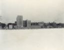
| Date: | 12 18 1955 |
|---|---|
| Description: | Downtown Madison lakeshore taken from Lake Monona in a line with South Carroll Street. Includes State Office Building (2 wings only), 1 West Wilson Street,... |

| Date: | 1955 |
|---|---|
| Description: | Aerial view of Cross Plains, with countryside surrounding and hills on the horizon. |

| Date: | 1956 |
|---|---|
| Description: | Aerial view looking northeast from a point over the east end of Middleton, showing the west end of Lake Mendota (right mid-ground). Fox Bluff juts into the... |

| Date: | 1955 |
|---|---|
| Description: | Aerial view of Atwood Avenue, looking west towards Winnebago Street and "Schenk's Corners." |

| Date: | 07 23 1953 |
|---|---|
| Description: | Queen of Apostles Seminary, 5810 Cottage Grove Road. |

| Date: | 1955 |
|---|---|
| Description: | Aerial view of the central traffic loop and Johnson Street expressway. |
If you didn't find the material you searched for, our Library Reference Staff can help.
Call our reference desk at 608-264-6535 or email us at: