Filter: Categories of Wisconsin Historical Images
Filter: Subject of Roads
Filter: County of Columbia
Filter: Categories of Wisconsin Historical Images
Filter: Subject of Roads
Filter: County of Columbia
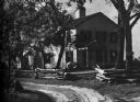
| Date: | 10 13 1911 |
|---|---|
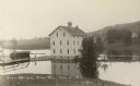
| Description: | Elevated view of a mill during a flood, with a man standing on the left between a bridge and the mill. A house is on the side of a tree-covered hill on the... |
| Date: | 1950 |
|---|---|
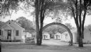
| Description: | Entrance sign and rainbow between two trees in front of several cabins at the Rainbow Cabins. The cabins were located on Route 16 on Vine Street. |

| Date: | 1930 |
|---|---|
| Description: | Exterior view of the Triangle filling station on Highway 12, which sold gasoline, ice, and other items. A man stands in front by the gas pump, and a map of... |
| Date: | |
|---|---|
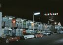
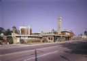
| Description: | Night view of gift shops, restaurants, and other attractions in a two-story shopping plaza. Several cars are parked along the curb beneath a streetlight in... |
| Date: | |
|---|---|
| Description: | Exterior view of Uphoff's Motel taken from across the street. The image shows a round section that was part of the original building known as Uphoff's Rotu... |

| Date: | 04 25 1970 |
|---|---|
| Description: | A smiling woman in a long pattered dress stands in the road as crowded cars slowly roll past, making a peace sign with her hands for a captive audience. |

| Date: | 04 25 1970 |
|---|---|
| Description: | A smiling woman in a long pattered dress stands in the road next to a crowded camper, making a peace sign with her hands for a captive audience. |
| Date: | |
|---|---|
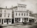
| Description: | Elevated view of storefront of Dixon's Canada Store. Dixon’s Canada Store was reputed to be the finest dry-goods emporium west of Milwaukee in the mid 1860... |
| Date: | |
|---|---|
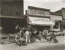
| Description: | A group of manual laborers posing for a portrait in front of a tailor's shop. The men apparently work pouring concrete to make sidewalks and are posing wit... |
| Date: | 1928 |
|---|---|
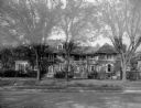
| Description: | An exterior view of the home of William Llewellyn and Zona Gale Breese. The brick and stucco house has features of several styles. The original 1912 struct... |
| Date: | 1936 |
|---|---|
| Description: | A view of the Indian Agency House, built in 1832. |
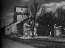
| Date: | 1936 |
|---|---|
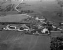
| Description: | A view of a small grain elevator and various other farm buildings near a road. |
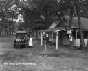
| Date: | 1929 |
|---|---|
| Description: | A man, woman, and child pose by a car near a tourist camping stop. |
| Date: | 1925 |
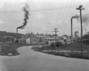
|---|---|
| Description: | Exterior of the Nestle Food Condensery plant. |

| Date: | 1911 |
|---|---|
| Description: | View down an unpaved road towards a four-story mill. Two boys pose on the side of the road. |

| Date: | 1861 |
|---|---|
| Description: | This 1861 map of Columbia County, Wisconsin, shows the township and range grid, towns, sections, cities and villages, railroads, roads, property owners and... |

| Date: | 1930 |
|---|---|
| Description: | This pictorial map from the first half of the 20th century shows the landmarks, highways, rail lines, and cities and villages in the vicinity of the Wiscon... |

| Date: | 1935 |
|---|---|
| Description: | This 1935 map shows the Wisconsin River from a point approximately 4 miles south of the city of Wisconsin Dells north to Duck Creek in Adams County. Sectio... |

| Date: | 1905 |
|---|---|
| Description: | Shows railroads, roads, post offices, creeks, lakes, and cities. Includes chart of deposits and total resources from the years 1890 to 1905. "First Natio... |
If you didn't find the material you searched for, our Library Reference Staff can help.
Call our reference desk at 608-264-6535 or email us at: