Filter: Categories of Wisconsin Historical Images
Filter: Subject of Roads
Filter: County of Columbia
Filter: Creator Name of Unknown
Filter: Categories of Wisconsin Historical Images
Filter: Subject of Roads
Filter: County of Columbia
Filter: Creator Name of Unknown

| Date: | 1874 |
|---|---|
| Description: | Bird's-eye map of Lodi, with inset of Public School. Includes index of churches and points of interest. |
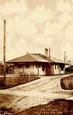
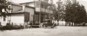
| Date: | 1908 |
|---|---|
| Description: | View down unpaved road towards the railroad station. Caption reads: "R. R. Station, Columbus, Wis." |
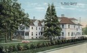
| Date: | 1910 |
|---|---|
| Description: | Lawn, trees and blooming flowers in front of St. Mary's Hospital. Caption reads: "St. Mary's Hospital, Columbus, Wis." |
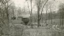
| Date: | 1930 |
|---|---|
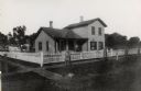
| Description: | View of a house among trees, and the surrounding landscape. |
| Date: | 1905 |
|---|---|
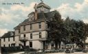
| Description: | View from road of the Hile House, Kilbourn (now Wisconsin Dells). There is a belvedere in the center of the roof. Caption reads: "Hile House, Kilbourn, Wis... |

| Date: | 1912 |
|---|---|
| Description: | View from road of the Briggs Hotel, which burned down in 1913. |

| Date: | 1875 |
|---|---|
| Description: | A view of the office of the Wisconsin State Resister. |
| Date: | 1890 |
|---|---|
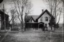
| Description: | The Turner-Rusch house. Frederick Jackson Turner's family lived here until 1882 when it was purchased by the Rusch Family. Julia Rusch was later (1950) pri... |
| Date: | |
|---|---|
| Description: | The residence of Frederick Jackson Turner. |
| Date: | 1880 |
|---|---|
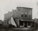
| Description: | The State Register newspaper office. This paper was published by Andrew Jackson Turner, father of Frederick Jackson Turner noted historian. Andrew Jackson ... |
| Date: | 1925 |
|---|---|
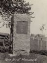
| Description: | The Red Bird monument, erected on the site of Ft. Winnebago and Red Bird's surrender. There is a cannon on the lawn behind the monument. A road is along th... |
| Date: | 1910 |
|---|---|
| Description: | A view of the Jacques Marquette and Louis Joliet marker. "This tablet marks the place near which Jacques Marquette and Louis Joliet entered the Wisconsin R... |
| Date: | 1924 |
|---|---|
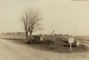
| Description: | Fort Winnebago monument two miles east of Portage on Highway 33, erected by the Wau-bun Chapter of the Daughters of the American Revolution in 1924. The mo... |
| Date: | 10 13 1911 |
|---|---|
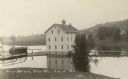
| Description: | Elevated view of a mill during a flood, with a man standing on the left between a bridge and the mill. A house is on the side of a tree-covered hill on the... |

| Date: | 1930 |
|---|---|
| Description: | This pictorial map from the first half of the 20th century shows the landmarks, highways, rail lines, and cities and villages in the vicinity of the Wiscon... |

| Date: | 1914 |
|---|---|
| Description: | This photostat map shows Fort Winnebago around 1931, land to be reserved for military purposes, roads to Fort Howard and Fort Crawford, "private property" ... |

| Date: | |
|---|---|
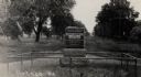
| Description: | Slightly elevated view of four horses pulling a stagecoach through a puddle on a dirt road. A group of children and adults are sitting on top of the stagec... |
If you didn't find the material you searched for, our Library Reference Staff can help.
Call our reference desk at 608-264-6535 or email us at: