Filter: Categories of Wisconsin Historical Images
Filter: Subject of Roads
Filter: County of Buffalo
Filter: Categories of Wisconsin Historical Images
Filter: Subject of Roads
Filter: County of Buffalo
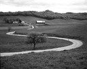
| Date: | 05 12 1963 |
|---|---|
| Description: | Winding farm road and distant farm with tree-covered hill in the background. |
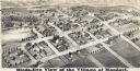
| Date: | 1877 |
|---|---|
| Description: | Bird's-eye map of Mondovi. |

| Date: | 04 21 1965 |
|---|---|
| Description: | View down flooded railroad tracks of the Chicago, Burlington & Quincy Railroad by the Mississippi River. There are houses on the left, and in the backgroun... |

| Date: | 1890 |
|---|---|
| Description: | Elevated view of people, horses, and wagons gathered in the center of Fountain City to celebrate McCormick Day. Scherer's Hotel is at left. The event was o... |
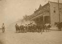
| Date: | |
|---|---|
| Description: | Farmers driving their cattle to a stockyard near the Burlington Depot, a weekly occurrence. |
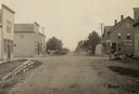
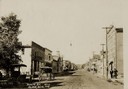
| Date: | 1910 |
|---|---|
| Description: | Main Street looking north. "Hotel and Saloon" are on the right side, along with other buildings down the right and left side. Main Street is a dirt road. T... |
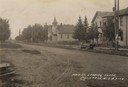
| Date: | 1910 |
|---|---|
| Description: | Southward view down the dirt Main Street, looking towards a house, two churches, and a grove of trees. |
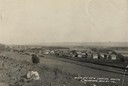
| Date: | 1910 |
|---|---|
| Description: | Slightly elevated view of Cochrane from a field. A road or highway stands between the field and Cochrane. Caption reads: "Birds [sic] Eye View Looki... |

| Date: | 1913 |
|---|---|
| Description: | Map from the U.S. Dept. of Agriculture's Soil Survey shows the soil types in Buffalo County, Wisconsin. The township and range grid, towns, sections, citie... |

| Date: | 1950 |
|---|---|
| Description: | Winter scene of a snow-covered hillside with a farm below. |

| Date: | 1856 |
|---|---|
| Description: | This map shows the city as planned by the General Colonization Society, including streets, land parcels, two subdivisions of out-lots with graveyard, schoo... |
If you didn't find the material you searched for, our Library Reference Staff can help.
Call our reference desk at 608-264-6535 or email us at: