Filter: Categories of Wisconsin Historical Images
Filter: Subject of Roads
Filter: County of Bayfield
Filter: Categories of Wisconsin Historical Images
Filter: Subject of Roads
Filter: County of Bayfield

| Date: | 1886 |
|---|---|
| Description: | Bird's-eye view of Bayfield, county seat of Bayfield County. On the lower left side is an inset for Bayfield and the Apostle Islands. |

| Date: | 1886 |
|---|---|
| Description: | Bird's-eye map of Washburn on Lake Superior. There is an inset of Washburn, Chequamagon and the Apostle Islands. |

| Date: | 1896 |
|---|---|
| Description: | Bird's-eye view of Washburn, with twenty vignettes around side, water in foreground with docks and lumber corral. Thirty-three locations identified in key ... |

| Date: | |
|---|---|
| Description: | Exterior view of the Washburn City Hall, which houses the Bank of Washburn. |
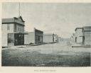
| Date: | |
|---|---|
| Description: | East Bayfield Street including a wagon on the street and a livery. |
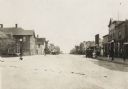
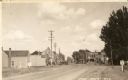
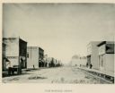
| Date: | 1916 |
|---|---|
| Description: | View looking down the center of road, with storefronts and dwellings on both sides. Automobiles and horse-drawn vehicles are parked at various points along... |
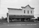
| Date: | |
|---|---|
| Description: | Exterior view from street of the storefront. Caption reads: "Tom Rondeau's General Store, Cable, Wis." |
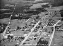
| Date: | 1936 |
|---|---|
| Description: | Aerial view of Cable, in northern Wisconsin. Text at foot reads: "Airplane View of Cable, Wis. 244." |
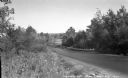
| Date: | 1936 |
|---|---|
| Description: | Guardrail along Highway 63, bordered with dense vegetation. |
| Date: | 1935 |
|---|---|
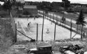
| Description: | View from above of spectators watching men play doubles tennis at a downtown tennis court. There is a water tower in the background. |
| Date: | 1935 |
|---|---|
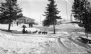
| Description: | Winter scene with people sledding, dog sledding, snowshoeing, and preparing for snowshoeing at Lakewood Country Club. |
| Date: | 1935 |
|---|---|
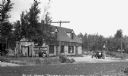
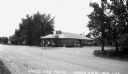
| Description: | View across road of automobile parked next to gasoline pump outside of the Blue Moon Tavern on County Highway 24. |

| Date: | 1935 |
|---|---|
| Description: | View across driveway of one-and-a-half story house with a stone chimney situated under large pine trees and new plantings. Cable Lake is in the background. |
| Date: | 1938 |
|---|---|
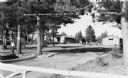
| Description: | Landscaped grounds under large white pine trees in the foreground, buildings in the background. A man is walking along the stone-lined road on the left, an... |
| Date: | 1935 |
|---|---|
| Description: | View across road of automobiles outside of service station. |
| Date: | 1935 |
|---|---|
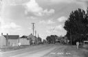
| Description: | Highway through Iron River on what is now Highway 2 near the junction with County Highway A. |
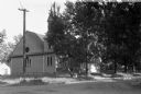
| Date: | 1935 |
|---|---|
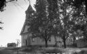
| Description: | Catholic Church with a bell tower. |
If you didn't find the material you searched for, our Library Reference Staff can help.
Call our reference desk at 608-264-6535 or email us at: