 Filter: Categories of Wisconsin Historical Images
Filter: Subject of Roads
Filter: County of Ashland
Filter: Categories of Wisconsin Historical Images
Filter: Subject of Roads
Filter: County of Ashland
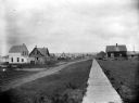
| Date: | 1910 |
|---|---|
| Description: | Looking west down wooden sidewalk along La Pointe's unpaved main street. |

| Date: | 1910 |
|---|---|
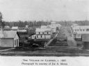
| Description: | View of La Pointe taken from Big Bay Road on Madeline Island. |
| Date: | 1897 |
|---|---|
| Description: | Dirt trail passing log shack that was probably the home of Michael and Madeline Cadotte. |

| Date: | 1886 |
|---|---|
| Description: | Bird's-eye view of Ashland, on the shores of Lake Superior, with insets of The Apostle Islands Chequamagon Bay & Ashland, and Distances from Ashland. |

| Date: | 1885 |
|---|---|
| Description: | Ore dock of the Milwaukee, Lake Shore, and Western Railroad, with a pile of logs in the foreground and docked ships in the background. |
| Date: | 1910 |
|---|---|
| Description: | Tom Stahl's dog team pulling wagon loaded with goods and child past buildings in La Pointe. |
| Date: | |
|---|---|
| Description: | Looking east at Terminal Moraine topography. View is down a dirt road with a house in the near background. |
| Date: | |
|---|---|
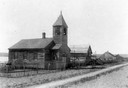
| Description: | Exterior view of Presbyterian Church with dirt path in front and wooden buildings in the background. |

| Date: | 1920 |
|---|---|
| Description: | Caption reads: "Mammoth Ore Docks, Ashland, Wis." A building and roads are in the foreground. Several ore ships can be seen. |
| Date: | 1910 |
|---|---|
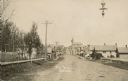
| Description: | View of Main Street when it was a dirt road. A church is in the background, and telephone poles are along the left side of the road. A streetlight is hangi... |
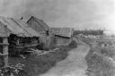
| Date: | 1885 |
|---|---|
| Description: | View of buildings in an industrial area with a forest in the background. |

| Date: | 1905 |
|---|---|
| Description: | View down road, with homes in a residential area, and a church building in the foreground on the right. The sign above the church door reads: "E. V. Luth. ... |
| Date: | 1913 |
|---|---|
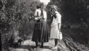
| Description: | Elizabeth Baker and Anne Ashley gathering raspberries and getting milk on the road to Grant's Point on Madeline Island. |
| Date: | 1913 |
|---|---|
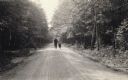
| Description: | A couple strolling down the main road, through the woods, to the mission on Madeline Island. |
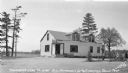
| Date: | 2008 |
|---|---|
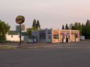
| Description: | When the East End Co-op Service Station opened in 1940 at the corner of Sixth Avenue and East Front Street, the owners announced, "Our new, modern equipmen... |
| Date: | 1937 |
|---|---|
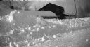
| Description: | Winter scene with snow piled high in front of Red Crown gasoline station. A man is standing next to the Red Crown gas pump. |
| Date: | 1937 |
|---|---|
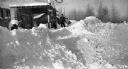
| Description: | Winter scene with snow plowed high on County Road M, Clam Lake (Ashland Co.), Wisconsin. The Chippewa Tavern is visible in the background, and the building... |

| Date: | 1937 |
|---|---|
| Description: | View from across road of a one-story building with stairs leading from the dirt road to the porch; an outhouse is behind the inn. Numerous beer signs are o... |
| Date: | 1937 |
|---|---|
| Description: | Gas pump and automobile next to a tavern on county Road D near Clam Lake. |
If you didn't find the material you searched for, our Library Reference Staff can help.
Call our reference desk at 608-264-6535 or email us at:
