 Filter: Categories of Wisconsin Historical Images
Filter: Subject of Roads
Filter: County of Adams
Filter: Categories of Wisconsin Historical Images
Filter: Subject of Roads
Filter: County of Adams

| Date: | 1986 |
|---|---|
| Description: | Panoramic view of the intersection of County Z and F, looking east from Z. The view shows several rural bars and restaurants. |
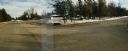
| Date: | 1987 |
|---|---|
| Description: | Panoramic view of the intersection of county highways Z (15th Avenue) and D in rural Adams County, looking east and south to a bar at the corner. |
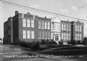
| Date: | |
|---|---|
| Description: | View from across road of the Adams and Friendship High School on Main Street. |
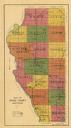
| Date: | 1916 |
|---|---|
| Description: | This early 20th century map of Adams County, Wisconsin, shows the township and range grid, towns, sections, cities and villages, roads, railroads, lakes an... |
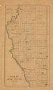
| Date: | 1900 |
|---|---|
| Description: | This map of Adams County, Wisconsin, from E.B. Foote's Plat book of Adams County, Wisconsin, 1900, shows the township and range grid, towns, sections, citi... |
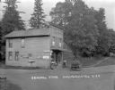
| Date: | 1922 |
|---|---|
| Description: | View from road of the general store, a two-story wood frame building in a rural area. A man and a child are standing near the door. Another child is sittin... |

| Date: | 1855 |
|---|---|
| Description: | This map is ink, pencil, and color on paper and shows property owners, a cemetery, farms, hotels, roads, a dike and on the back are additional notes. Notes... |

| Date: | |
|---|---|
| Description: | View of Friendship Mound — a rocky outcropping, from the road below. |

| Date: | |
|---|---|
| Description: | Hand-colored postcard of Rabbit Rock — a rocky outcropping with two towers of stone. |

| Date: | |
|---|---|
| Description: | Three young people are standing on Rabbit Rock, two of them in the foreground, and one on top of the taller peak. Highway 13 is below in the background. |
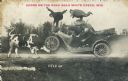
| Date: | 1915 |
|---|---|
| Description: | Text on front reads: "Scene on the Road Near White Creek, Wis." and at the bottom: "Held Up". Photomontage of a cow, an automobile and five men. The automo... |
If you didn't find the material you searched for, our Library Reference Staff can help.
Call our reference desk at 608-264-6535 or email us at: