 Filter: Categories of Wisconsin Historical Images
Filter: Subject of Roads
Filter: Community of Wauwatosa
Filter: Categories of Wisconsin Historical Images
Filter: Subject of Roads
Filter: Community of Wauwatosa

| Date: | 1892 |
|---|---|
| Description: | Color bird's-eye map of Wauwatosa, looking east toward Milwaukee and Lake Michigan. Predominantly green with cream colored roadways, with six land plots ow... |
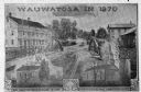
| Date: | 1870 |
|---|---|
| Description: | An advertisement featuring Wauwatosa, showing the First Baptist Church, on the left, built in 1854 and the First Congregational Church, on the right built ... |
| Date: | 1917 |
|---|---|
| Description: | The intersection of Green Bay and Cedarburg roads taken for Wisconsin Highway Department. |
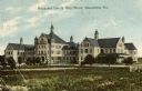
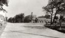
| Date: | 1917 |
|---|---|
| Description: | The Milwaukee County Alms House. Caption reads: "Milwaukee County Alms House, Wauwatosa, Wis." |
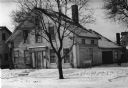
| Date: | 1935 |
|---|---|
| Description: | The Lowell Damon house, east elevation or front. Snow is on the ground. |

| Date: | 1939 |
|---|---|
| Description: | This is a zoning map of Wauwatosa with a key of districts including agricultural, resident, business, commercial, and industrial. The map features labeled ... |
If you didn't find the material you searched for, our Library Reference Staff can help.
Call our reference desk at 608-264-6535 or email us at: