Filter: Categories of Wisconsin Historical Images
Filter: Subject of Roads
Filter: Community of Waterford
Filter: Categories of Wisconsin Historical Images
Filter: Subject of Roads
Filter: Community of Waterford
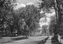
| Date: | 1920 |
|---|---|
| Description: | View of a street and homes, taken from the sidewalk. The trees lining the street partially obscure the houses in the foreground. |

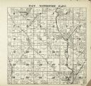
| Date: | 1887 |
|---|---|
| Description: | A plat map of Waterford. Township 4, North Range 19, East of 4th Principal Meridian. References at bottom include school houses, houses, churches and cemet... |
If you didn't find the material you searched for, our Library Reference Staff can help.
Call our reference desk at 608-264-6535 or email us at: