Filter: Categories of Wisconsin Historical Images
Filter: Subject of Roads
Filter: Community of Washburn
Filter: Categories of Wisconsin Historical Images
Filter: Subject of Roads
Filter: Community of Washburn

| Date: | 1886 |
|---|---|
| Description: | Bird's-eye map of Washburn on Lake Superior. There is an inset of Washburn, Chequamagon and the Apostle Islands. |

| Date: | 1896 |
|---|---|
| Description: | Bird's-eye view of Washburn, with twenty vignettes around side, water in foreground with docks and lumber corral. Thirty-three locations identified in key ... |

| Date: | |
|---|---|
| Description: | Exterior view of the Washburn City Hall, which houses the Bank of Washburn. |
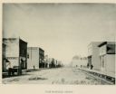
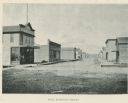
| Date: | |
|---|---|
| Description: | East Bayfield Street including a wagon on the street and a livery. |
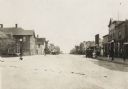
| Date: | 1916 |
|---|---|
| Description: | View looking down the center of road, with storefronts and dwellings on both sides. Automobiles and horse-drawn vehicles are parked at various points along... |
If you didn't find the material you searched for, our Library Reference Staff can help.
Call our reference desk at 608-264-6535 or email us at: