Filter: Categories of Wisconsin Historical Images
Filter: Subject of Roads
Filter: Community of Sparta
Filter: Categories of Wisconsin Historical Images
Filter: Subject of Roads
Filter: Community of Sparta

| Date: | 06 02 1943 |
|---|---|
| Description: | Looking west down road towards the bridge. The roadway is damaged in two spots, leaving large gaps. The walls of the bridge are still intact. Traffic barri... |
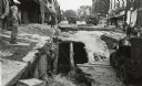
| Date: | 06 02 1943 |
|---|---|
| Description: | Looking south down street, with storefronts on either side. The street and bridge are undergoing reconstruction. Military vehicles are in the background. |
| Date: | 06 02 1943 |
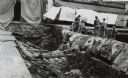
|---|---|
| Description: | Looking Northwest. Workers are standing on the right next to the exposed drainage pipes in the damaged bridge. Sheets and quilts are covering the entranc... |
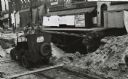
| Date: | 06 02 1943 |
|---|---|
| Description: | Looking south. A jeep sits in the middle of the construction zone. The storefronts are covered with quilts and blankets. |

| Date: | |
|---|---|
| Description: | Exterior view from road of the Sparta Public Library. Reverse of the cardboard backing reads: "Carnegie bldg., 1903, cost $12,000. Architects, Schick & Rot... |
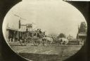
| Date: | 1863 |
|---|---|
| Description: | Photographic postcard of a stagecoach pulled by four horses in the road in front of a harness shop. Two men sit in the upper seat. A handful of people stan... |

| Date: | 1940 |
|---|---|
| Description: | This maps shows the areas in Monroe, Jackson, and Juneau counties, Wisconsin, where U.S. Army maneuvers were held in August 1940. Highways and roads, commu... |
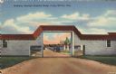
| Date: | |
|---|---|
| Description: | Colorized postcard view of an arch at Camp McCoy with ramps on either side and a road passing through it. Parked cars and barracks are on the far side of t... |

| Date: | 1909 |
|---|---|
| Description: | This is one of a set of two topographical maps showing land use, roads, railroads, bridges, and buildings with ownership in parts of LaFayette, Greenfield,... |

| Date: | 1909 |
|---|---|
| Description: | This the second of a set of two topographical maps showing land use, roads, railroads, bridges, and buildings with ownership in parts of LaFayette, Greenfi... |

| Date: | 05 26 1947 |
|---|---|
| Description: | View across road and fields towards three wooded hill peaks. A roadside fence is in the foreground. Caption reads: "D.A. 36-268 — Three peaks on Hy.71 betw... |
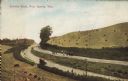
| Date: | 1907 |
|---|---|
| Description: | Text on front reads: "County Road, Near Sparta, Wis." Elevated view of a group of people standing on an unpaved county road that runs through a cut in a hi... |
If you didn't find the material you searched for, our Library Reference Staff can help.
Call our reference desk at 608-264-6535 or email us at: