 Filter: Categories of Wisconsin Historical Images
Filter: Subject of Roads
Filter: Community of Madison
Filter: Categories of Wisconsin Historical Images
Filter: Subject of Roads
Filter: Community of Madison

| Date: | 1908 |
|---|---|
| Description: | A panoramic aerial view of the Isthmus taken from a kite. Lake Mendota is to the right in the background with Picnic Point jutting into the lake. The photo... |
| Date: | 1917 |
|---|---|
| Description: | Exterior view of the Municipal Market, which was built in 1910 but not operated successfully until July 1917 when it was run by a group of women from the D... |

| Date: | 06 07 1954 |
|---|---|
| Description: | Aerial view of the Midvale neighborhood under construction showing the intersection of Midvale and Tokay Boulevards near the southwestern city limits of Ma... |

| Date: | 06 07 1954 |
|---|---|
| Description: | Aerial view looking north from near the city's southwestern limits in 1954. Shows text indicating Midvale Boulevard, Odana Road, Tokay Boulevard, Mineral P... |

| Date: | 1955 |
|---|---|
| Description: | Aerial view of Midvale neighborhood under construction near Madison's southwestern city limits. The view is focused on the area bounded by Tokay Boulevard,... |
| Date: | 08 07 1929 |
|---|---|
| Description: | Bondi & Sachtjen Texaco service station, 1462 E. Washington Avenue at Thornton Avenue, with Fuller & Johnson buildings in the background. Text with print r... |
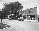
| Date: | 06 14 1927 |
|---|---|
| Description: | Storefronts of the Wisconsin School of Music, East Side Variety Store and Hess Grocery Market. Owned by the Hess family, this property was located at 154 A... |
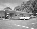
| Date: | 1958 |
|---|---|
| Description: | 2700 Marshall Court, Doctor's Park, Shorewood Hills. |

| Date: | 1958 |
|---|---|
| Description: | Aerial view of Craig Avenue and Crestwood Avenue. |
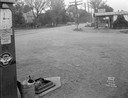
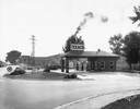
| Date: | 09 30 1933 |
|---|---|
| Description: | Gas station in a Trachte building on the corner of Highway 51 (Monona Drive) and Highway 30 (Cottage Grove Road). A "Johnson Winged 70 Gasoline" pump is in... |
| Date: | 09 30 1933 |
|---|---|
| Description: | A gas station in a Trachte building on the corner of Highway 51 (Monona Drive) and Highway 30 (Cottage Grove Road). "Johnson Gasoline," and "Defiance Spark... |
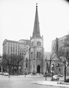
| Date: | 11 24 1946 |
|---|---|
| Description: | Built in 1855 and designed by Milwaukee architect James Douglas, the Grace Episcopal Church is the oldest remaining building on the Capitol Square. Grace E... |
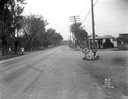
| Date: | 10 12 1934 |
|---|---|
| Description: | Automobile and truck accident at the corner of Milton Street and West Washington Avenue in the Greenbush neighborhood. A crowd has gathered to observe the ... |
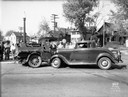
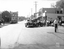
| Date: | 10 12 1934 |
|---|---|
| Description: | Automobile and truck crash at the corner of Milton and West Washington Avenue in the Greenbush neighborhood. Houses in the 600 block of Milton Street are i... |

| Date: | 05 09 1908 |
|---|---|
| Description: | Kite aerial panoramic photograph of the central business district. In the distance is Lake Mendota. The fire damaged Wisconsin State Capitol is in the cent... |

| Date: | 1861 |
|---|---|
| Description: | View of Madison from Main Hall, now Bascom Hall, on the University of Wisconsin-Madison campus looking up State Street toward the second Wisconsin State Ca... |

| Date: | 1910 |
|---|---|
| Description: | Map of Dane County rural delivery in Madison and the town of Westport. |

| Date: | 1832 |
|---|---|
| Description: | Hand-drawn map in two parts of the route of Governor J.D. Doty. Probably made by Doty in 1832 as a result of his travels with Alexander J. Center. |

| Date: | 1879 |
|---|---|
| Description: | Bird's-eye view of Wisconsin State University, now the University of Wisconsin-Madison. Vignettes include Ladies Hall, South Dormitory, University Hall, As... |
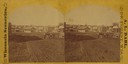
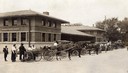
| Date: | 1874 |
|---|---|
| Description: | View looking southwest down the 600 block of Williamson Street to the East Madison Passenger Depot of the Chicago & Northwestern Railroad. There are frame ... |
If you didn't find the material you searched for, our Library Reference Staff can help.
Call our reference desk at 608-264-6535 or email us at: