 Filter: Categories of Wisconsin Historical Images
Filter: Subject of Roads
Filter: Community of Fond du Lac
Filter: Categories of Wisconsin Historical Images
Filter: Subject of Roads
Filter: Community of Fond du Lac

| Date: | 1867 |
|---|---|
| Description: | Birds eye drawing of Fond du Lac depicts street names and street layouts, houses, buildings, trees, and the Fond du Lac River. A reference key at the botto... |

| Date: | 1913 |
|---|---|
| Description: | The stone and iron gateway entrance to St. Mary's Springs Academy. Caption reads: "Entrance to St. Mary's Springs Academy Fond du Lac, Wis." |

| Date: | 1905 |
|---|---|
| Description: | View across road towards two women standing on the sidewalk in front of Bishop Grafton's residence. Caption reads: "Bishop Grafton's Residence, Fond du Lac... |

| Date: | 1920 |
|---|---|
| Description: | View from road towards the gates of the Buena Vista house on Lake de Neveu. Caption reads: "The House Buena Vista The de Neveu Farm". |

| Date: | 1905 |
|---|---|
| Description: | Grafton Hall front entrance with a street running in front. A bicycle leans against the building near the entrance. |
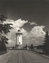
| Date: | 1954 |
|---|---|
| Description: | View down road towards the Fond du Lac lighthouse, built in 1933. There are cumulus clouds in the sky, and pine trees are lining the shore. |
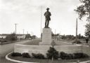
| Date: | 1936 |
|---|---|
| Description: | View of a boulevard containing a Spanish war memorial statue. The plaque on the statue's base reads: "Memorial to those who served in the war with Spain, 1... |
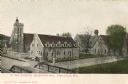
| Date: | 1910 |
|---|---|
| Description: | View over bridge towards St. Paul Cathedral and Grafton Hall. Caption reads: "St Paul Cathedral and Grafton Hall, Fond du Lac, Wis." |

| Date: | 1857 |
|---|---|
| Description: | A quarter section of a map of the City of Fond du Lac featuring the Empire Branch Plank Road. |

| Date: | 1857 |
|---|---|
| Description: | Quarter section of a map of the city of Fond du Lac featuring the Waupun Plank Road. |

| Date: | 1862 |
|---|---|
| Description: | Birds-eye view of a Wisconsin Civil War regiment on parade in Fond du Lac, as drawn by Louis Kurz from the Marr Street Methodist Church. The regiment canno... |
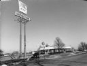
| Date: | 11 24 2000 |
|---|---|
| Description: | "On this Friday we are at Kentucky Fried Chicken in Fond du Lac, WI." |
| Date: | 1890 |
|---|---|
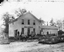
| Description: | Exterior view from across road of men gathered outside a store and saloon. Most of the men hold a glass of beer as though toasting. Two teams of horses are... |

| Date: | 1862 |
|---|---|
| Description: | This map shows townships and sections, landownership and acreages, roads, railroads, cemeteries, churches, schools, mills, and stone quarries. "Engraved, p... |

| Date: | 1904 |
|---|---|
| Description: | Map shows townships and sections, landownership and acreages, roads and railroads, and selected buildings. "1904" inscribed on map in pen. Includes busines... |

| Date: | 1956 |
|---|---|
| Description: | Includes street index. Shows local streets, parks, highways, railroads, Fond du Lac River, and part of lake Winnebago. Also includes text on points of inte... |

| Date: | |
|---|---|
| Description: | Plaque marker identifying the “Pioneer Military Road” route from Fort Howard at Green Bay to Fort Crawford at Prairie du Chien. |

| Date: | 1857 |
|---|---|
| Description: | This map has relief shown by hachures and pictorially and shows plat of the town, wards, lots, land ownership by name, local roads, highways, railroads, pa... |

| Date: | 1836 |
|---|---|
| Description: | This map shows land parcels, streets, the Fond du Lac River, Lake Winnebaygo (Winnebago), and blocks. Certification is on the left hand corner. The back of... |
If you didn't find the material you searched for, our Library Reference Staff can help.
Call our reference desk at 608-264-6535 or email us at:
