 Filter: Categories of Wisconsin Historical Images
Filter: Subject of Roads
Filter: Community of Blooming Grove
Filter: Categories of Wisconsin Historical Images
Filter: Subject of Roads
Filter: Community of Blooming Grove

| Date: | 1911 |
|---|---|
| Description: | Plat Map of Blooming Grove in "Atlas of Dane County, Wisconsin." |
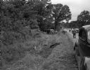
| Date: | 08 17 1946 |
|---|---|
| Description: | Skid-path of the Greyhound bus that crashed on Highway 12 about 2 miles east of Madison. The bus left the highway, plunged 200 feet along a ditch, hit a d... |
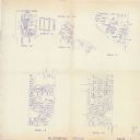
| Date: | 1993 |
|---|---|
| Description: | This collection of maps includes two pages of seven detailed plats of different sub divisions and areas of the township. |

| Date: | |
|---|---|
| Description: | Aerial view looking west along Pflaum Road taken from the east of Stoughton Road, Monona, and Lake Monona in the distance. The Wisconsin State Capitol and ... |
If you didn't find the material you searched for, our Library Reference Staff can help.
Call our reference desk at 608-264-6535 or email us at: