 Filter: Categories of Wisconsin Historical Images
Filter: Subject of Roads
Filter: Community of Baraboo
Filter: Categories of Wisconsin Historical Images
Filter: Subject of Roads
Filter: Community of Baraboo

| Date: | 1935 |
|---|---|
| Description: | Civilian Conservation Corps workers at the Devil's Lake State park camp waving from trucks. Others men stand in the dirt road nearby. |
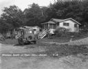
| Date: | 1929 |
|---|---|
| Description: | An automobile is parked at the side of the road near tourist cabins at Panoramic Resort at Devil's Lake. |

| Date: | 1944 |
|---|---|
| Description: | Motorcycle police at the Badger Ordnance plant in Baraboo, Wisconsin, between 1942 and 1945. These men patrolled the fence line of the plant. One of the gu... |

| Date: | 1920 |
|---|---|
| Description: | This map of Devil's Lake State Park in Sauk County, Wisconsin, shows the park limits, railroads, roads, creeks, trails, and points of interest in the area.... |

| Date: | 1923 |
|---|---|
| Description: | This topographical map of Devil's Lake State Park, Sauk County, Wisconsin, is based on 1922-1923 surveys of the area by the University of Wisconsin Summer ... |

| Date: | 1926 |
|---|---|
| Description: | Map showing Devil's Lake State Park limits, railroads, roads, creeks, trails, and park sites. Accompanying text about the location, natural features, attra... |

| Date: | 1915 |
|---|---|
| Description: | This 1915 map covers the section of the Wisconsin River in southern Adams, southeastern Juneau, northeastern Sauk, and northwestern Columbia counties. A po... |
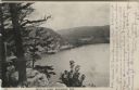
| Date: | 1906 |
|---|---|
| Description: | View from bluff of Devil's Lake. A road runs along the far shoreline. Caption reads: "Devil's Lake, Baraboo, Wis." |

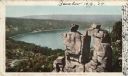
| Date: | 1909 |
|---|---|
| Description: | Elevated view of the Baraboo River. The main part of town is on the far left shoreline. On the right industrial buildings are near a bridge spanning the ri... |
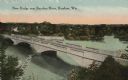
| Date: | 1919 |
|---|---|
| Description: | Colorized postcard of an elevated view of a concrete bridge over a river. There is a boat near wooden pilings that stretch from the shoreline to the center... |
| Date: | 1898 |
|---|---|
| Description: | Colorized postcard view of the Devil's Doorway rock formation overlooking Devil's Lake. Caption reads: "Devil's Doorway, Devil's Lake, Wis." |
| Date: | 08 06 2012 |
|---|---|
| Description: | The north entrance to Devil's Lake State Park. The entrance is flanked by two fieldstone pillars. |

| Date: | 1903 |
|---|---|
| Description: | This blue line print shows quartzite areas, mines, railroads, and roads. The map covers townships 11-13 north, ranges 4-8 east, in parts of Sauk and Columb... |

| Date: | |
|---|---|
| Description: | A vintage view and a modern view of the entrance to Devil's Lake State Park, presented as a pair. The vintage view features an information center and there... |

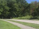
| Date: | |
|---|---|
| Description: | View down road. On the left is a large tree with bright orange leaves. |
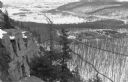
| Date: | 1935 |
|---|---|
| Description: | Elevated view, from the South Bluff, of the CCC camp at Devil's Lake State Park. There is a rock outcropping in the foreground on the left. South Shore Roa... |

| Date: | 1935 |
|---|---|
| Description: | The bluffs and lake appear hazy beyond an unpaved road and simple wooden bridge at Devil's Lake State Park. A man or boy at the shoreline can be seen throu... |
If you didn't find the material you searched for, our Library Reference Staff can help.
Call our reference desk at 608-264-6535 or email us at: