 Filter: Categories of Wisconsin Historical Images
Filter: Subject of Roads
Filter: Community of Baraboo
Filter: Year of 1900-1999
Filter: Creator Name of Unknown
Filter: Categories of Wisconsin Historical Images
Filter: Subject of Roads
Filter: Community of Baraboo
Filter: Year of 1900-1999
Filter: Creator Name of Unknown
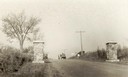
| Date: | 1925 |
|---|---|
| Description: | View of the memorial pillars on the Warner Memorial Road near Baraboo. The pillars were erected in 1923. |

| Date: | 1929 |
|---|---|
| Description: | View of a man driving an automobile on a dirt road in Ableman. Rock formations are on both sides of the road, and rocks and trees are in the background. |

| Date: | 08 21 1952 |
|---|---|
| Description: | From left to right are Lewis, Nellie and Bernard Arms posing behind a convertible on Old Lake Road, with Bernard and Nellie's house in the background. |

| Date: | 1955 |
|---|---|
| Description: | Bernard Arms's dog Tuffy plays outdoors, with Lewis Arms' 1949 Pontiac automobile parked in the grass in the background. |
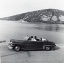
| Date: | 1956 |
|---|---|
| Description: | Lewis, LuRay, Nellie and Bernard Arms arrive at Devil's Lake in a maroon DeSoto convertible automobile. This was the day after Lewis and LuRay's wedding. |
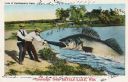
| Date: | 07 28 1933 |
|---|---|
| Description: | Colorized postcard in the Tall-Tale style. Two men standing on the shore are pulling a third man's leg out of a enormous fish's mouth. Two automobiles and ... |

| Date: | 12 29 1909 |
|---|---|
| Description: | Colorized postcard of the rock formation called the Devil's Doorway in Devil's Lake State Park. Trees are on the left and below. Bluffs, trees, sky and a r... |

| Date: | 1935 |
|---|---|
| Description: | Civilian Conservation Corps workers at the Devil's Lake State park camp waving from trucks. Others men stand in the dirt road nearby. |

| Date: | 1944 |
|---|---|
| Description: | Motorcycle police at the Badger Ordnance plant in Baraboo, Wisconsin, between 1942 and 1945. These men patrolled the fence line of the plant. One of the gu... |

| Date: | 1923 |
|---|---|
| Description: | This topographical map of Devil's Lake State Park, Sauk County, Wisconsin, is based on 1922-1923 surveys of the area by the University of Wisconsin Summer ... |

| Date: | 1909 |
|---|---|
| Description: | Elevated view of the Baraboo River. The main part of town is on the far left shoreline. On the right industrial buildings are near a bridge spanning the ri... |

| Date: | 1903 |
|---|---|
| Description: | This blue line print shows quartzite areas, mines, railroads, and roads. The map covers townships 11-13 north, ranges 4-8 east, in parts of Sauk and Columb... |

| Date: | 1935 |
|---|---|
| Description: | The bluffs and lake appear hazy beyond an unpaved road and simple wooden bridge at Devil's Lake State Park. A man or boy at the shoreline can be seen throu... |
If you didn't find the material you searched for, our Library Reference Staff can help.
Call our reference desk at 608-264-6535 or email us at: