 Filter: Categories of Wisconsin Historical Images
Filter: Subject of Roads
Filter: Community of Appleton
Filter: Categories of Wisconsin Historical Images
Filter: Subject of Roads
Filter: Community of Appleton
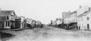
| Date: | 1860 |
|---|---|
| Description: | College Avenue looking west from the corner of Morrison Street. The building on the left is the Adkins Building, at the right is the Johnston House. This w... |

| Date: | 1867 |
|---|---|
| Description: | Birds-eye drawing of Appleton, Outagamie Co., depicting street names and street layout, houses, the Fox River, the court house, jail, school houses, Lawren... |

| Date: | 1930 |
|---|---|
| Description: | Aerial view of the city and the river. |
| Date: | 1886 |
|---|---|
| Description: | The first electric street railway in Wisconsin. |
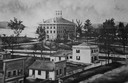
| Date: | 1860 |
|---|---|
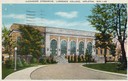
| Description: | Elevated illustration of the Lawrence College Campus with snow on the ground. |
| Date: | 1909 |
|---|---|
| Description: | View down Lover's Lane. Caption reads: "Lover's Lane, Appleton, Wis." |
| Date: | 1934 |
|---|---|
| Description: | View down drive toward the gymnasium. Caption reads: "Alexander Gymnasium, Lawrence College, Appleton, Wis." |
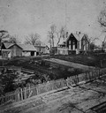
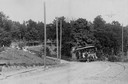
| Date: | |
|---|---|
| Description: | Elevated view across road and fence towards two houses and a yard, bordered by a damaged, white picket fence. The house burned down in 1867. |
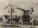
| Date: | 1885 |
|---|---|
| Description: | This is the H.W. Tenney house built by Charles Patten in the late 1870's, bought by Mr. Tenney in the spring of 1881. The people are, (left to right): Eva ... |
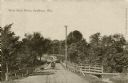
| Date: | 1911 |
|---|---|
| Description: | View down center of West Park Drive. There is a man driving an automobile on the bridge. Caption reads: "West Park Drive, Wis." |

| Date: | 1870 |
|---|---|
| Description: | Congregational Church, also called the "old brown church" built in 1853 and burned in 1893. It was on the site of the present City Hall. The white house ne... |
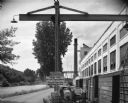
| Date: | 08 05 1962 |
|---|---|
| Description: | Exterior view of Riverside Paper Corporation mill. On the left is a road along a river, and on the right are railroad tracks along the mill. A sign in the ... |
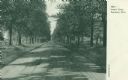
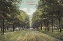
| Date: | 1906 |
|---|---|
| Description: | View looking down tree-lined Lovers' Lane. Caption reads: "Lovers' Lane, Appleton, Wis." |
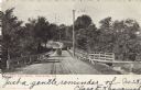
| Date: | 04 1906 |
|---|---|
| Description: | View of West Park Drive. Wooden railings line the road and a wooden walkway is on the right. A man wearing a cap is driving an automobile across the drive.... |
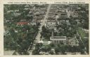
| Date: | |
|---|---|
| Description: | Aerial view of College Avenue looking west. Several campus buildings at Lawrence College are in the foreground. Caption reads: "College Avenue looking West... |
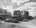
| Date: | 1960 |
|---|---|
| Description: | Exterior of Olsen's Mill (Wayne Feeds) on Hwy 49, just north of Hwy 21. |

| Date: | 1952 |
|---|---|
| Description: | Map shows roads, highways, railroads, parks, city buildings, schools, cemeteries, city limits, and the Fox River. The map is indexed by street name, street... |

| Date: | 1874 |
|---|---|
| Description: | Bird's-eye view map of Appleton, Wisconsin. Map reads: "NOTE.-Since the above cut was engraved, the Fox River Pulp & Paper Co.'s Mammoth Mills have been er... |

| Date: | 1916 |
|---|---|
| Description: | Map shows roads, railroads, the Fox River, parks, and cemeteries. Wards are numbered and the edges of the map feature coordinates. The top left of the map ... |
If you didn't find the material you searched for, our Library Reference Staff can help.
Call our reference desk at 608-264-6535 or email us at:
