 Filter: Categories of Wisconsin Historical Images
Filter: Subject of Roads
Filter: Creator Name of Unknown
Filter: Year of 1800-1899
Filter: Categories of Wisconsin Historical Images
Filter: Subject of Roads
Filter: Creator Name of Unknown
Filter: Year of 1800-1899
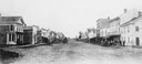
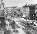
| Date: | 1860 |
|---|---|
| Description: | College Avenue looking west from the corner of Morrison Street. The building on the left is the Adkins Building, at the right is the Johnston House. This w... |
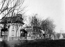
| Date: | 1890 |
|---|---|
| Description: | Several houses at the intersection of Wilson Street and Monona Avenue with the home of Simeon Mills, one of Madison's most prominent citizens, on the corne... |
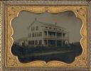
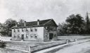
| Date: | 1858 |
|---|---|
| Description: | Ambrotype of the Wade House, a carriage inn located in Greenbush, also showing a section of the original plank road in the foreground. |
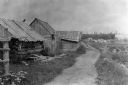
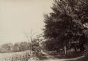
| Date: | 1897 |
|---|---|
| Description: | Dirt trail passing log shack that was probably the home of Michael and Madeline Cadotte. |
| Date: | 1890 |
|---|---|
| Description: | Hagerstown Pike. A brick wall and trees are along the road on the right. |

| Date: | 1873 |
|---|---|
| Description: | Map of the township of Windsor, from the "Atlas of Dane County." |
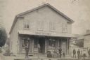
| Date: | 1888 |
|---|---|
| Description: | Exterior view of Charles Pfeifer's Drugstore, founded in 1858. From left to right are Charles Pfeifer, Fred Pfeifer, Mrs. Adam Heeb, Fulda Pfeifer, Mrs. Ch... |
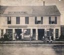
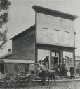
| Date: | 1864 |
|---|---|
| Description: | Street scene with customers in front of the M.P. Roberts Drugstore and C. Baack Flour and Feed Store. |
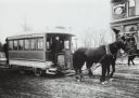
| Date: | 1890 |
|---|---|
| Description: | Man driving a horse-drawn trolley of the Milwaukee City Railroad Company on the Greenfield Avenue & Third Street line. The corner of a building advertising... |
| Date: | 1892 |
|---|---|
| Description: | Caption: "Stage driven by William C. Alden stopping in front of Coon Valley store on the route between Viroqua to Muscoda and La Crosse. Alden drove the st... |
| Date: | 1870 |
|---|---|
| Description: | Buildings along Wisconsin Avenue lining a wide dirt road. |

| Date: | 1876 |
|---|---|
| Description: | Bird's-eye view of Black Earth. |

| Date: | 1876 |
|---|---|
| Description: | Bird's-eye view of Middleton with an inset of a school house. |
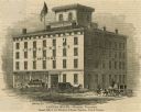
| Date: | 1853 |
|---|---|
| Description: | Illustration of the Capital house, a first-class hotel, copied from page 320 of Gleason's Pictorial Drawing-Room Companion. |
| Date: | 1848 |
|---|---|
| Description: | Sketch of the Madison Women's Seminary on the corner of Wisconsin Avenue and East Johnson. The Madison Female Academy was a 19th century school for girls w... |

| Date: | 1874 |
|---|---|
| Description: | Bird's-eye map of Lodi, with inset of Public School. Includes index of churches and points of interest. |
| Date: | 1877 |
|---|---|
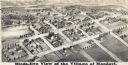
| Description: | Bird's-eye map of Mondovi. |

| Date: | 1860 |
|---|---|
| Description: | Bird's-eye drawing of New Glarus. |
| Date: | 1880 |
|---|---|
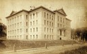
| Description: | View across Park Street of Science Hall at the base of Bascom Hill on the University of Wisconsin Madison campus. |
| Date: | 1880 |
|---|---|
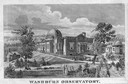
| Description: | Washburn Observatory on the University on Wisconsin-Madison campus, with pedestrians on the surrounding grounds. |
If you didn't find the material you searched for, our Library Reference Staff can help.
Call our reference desk at 608-264-6535 or email us at: