 Filter: Categories of Wisconsin Historical Images
Filter: Subject of Roads
Filter: Creator Name of Milwaukee Lithographing & Engraving Co.
Filter: Categories of Wisconsin Historical Images
Filter: Subject of Roads
Filter: Creator Name of Milwaukee Lithographing & Engraving Co.
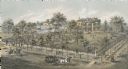
| Date: | 1872 |
|---|---|
| Description: | Lithograph elevated view of the Alexander Mitchell home and gardens seen from the corner of Ninth and Spring Streets. Pedestrians, horse-riders and a horse... |

| Date: | 1896 |
|---|---|
| Description: | This 1898 map shows the township and range system, sections, cities and villages, railroads, roads, vacant land and land sold by the Wisconsin Central Rail... |

| Date: | 1900 |
|---|---|
| Description: | This 1900 map shows the township and range system, sections, cities and villages, railroads, roads, vacant land and land sold by the Wisconsin Central Rail... |
If you didn't find the material you searched for, our Library Reference Staff can help.
Call our reference desk at 608-264-6535 or email us at: