Filter: Categories of Wisconsin Historical Images
Filter: Subject of Roads
Filter: Creator Name of Gillett, Sherwin
Filter: Subject of trees
Filter: Categories of Wisconsin Historical Images
Filter: Subject of Roads
Filter: Creator Name of Gillett, Sherwin
Filter: Subject of trees
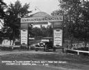
| Date: | 07 1927 |
|---|---|
| Description: | Car parked underneath the entrance gate to the Island Resort at the Wisconsin Dells, 25 miles from the Dells on Highway 12-16 near Mauston. Entrance gate a... |
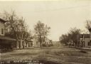
| Date: | 1909 |
|---|---|
| Description: | Text on front reads: "Main Street Looking South, Lone Rock, Wis." Unpaved street with sidewalks, dwellings and buildings on both sides. Horse drawn vehicle... |
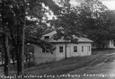
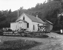
| Date: | 1926 |
|---|---|
| Description: | Caption reads: "Chapel at Willerup Camp — Lake Ripley — Cambrdige. Wis." The camp was named for the Danish immigrant minister, Christian B. Willerup, who e... |
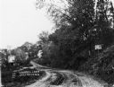
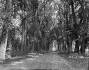
| Date: | 1911 |
|---|---|
| Description: | View of a dirt road winding through a forested area. A building is up the hill to the right of the road. |
| Date: | 1925 |
|---|---|
| Description: | Free public campground at Baraboo, one of 200 such facilities then made available to the traveling public by Wisconsin municipalities. |
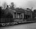
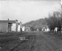
| Date: | 1911 |
|---|---|
| Description: | View down an unpaved Merrimac street with a brick building and horse-drawn carriages. The caption at bottom left reads: "A Fine Business Block." |
| Date: | 1924 |
|---|---|
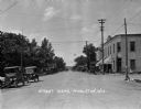
| Description: | View down road lined with trees and storefronts. A number of automobiles can be seen parked. The Post Office is on the right. |
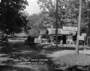
| Date: | 1924 |
|---|---|
| Description: | A view down street, which is lined with parked cars. There is a grocery store on the corner on the right, and beyond is a sign for a "Hotel Office". |
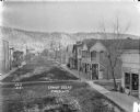
| Date: | 1909 |
|---|---|
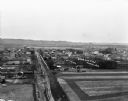
| Description: | An elevated view of a town in the Wisconsin River Valley. Fields surround the town, and low hills are in the far background. |
| Date: | 1912 |
|---|---|
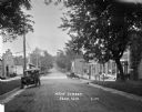
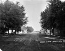
| Description: | Elevated view of a wide main street through town. Pedestrians are on sidewalks on both sides of the dirt street. A church steeple is visible in the backgro... |
| Date: | 1915 |
|---|---|
| Description: | View down street of with commercial buildings and dwellings. There are two carriages parked near a building which has part of a sign visible over the entra... |
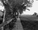
| Date: | 1912 |
|---|---|
| Description: | View down wooden walkway with a dwelling, trees and backyards on the left and an open area on the right. |
| Date: | 1921 |
|---|---|
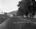
| Description: | View down unpaved Main Street. A row of houses are on either side of the road, and there is a steep hill in the background. |
| Date: | 1921 |
|---|---|
| Description: | View down a tree-lined dirt road. Houses and shops line both sides of the road, and men and children are sitting and playing on the sidewalks. In the far d... |
| Date: | 1921 |
|---|---|
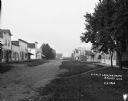
| Description: | View down dirt road line with trees and houses on the right side. On the left side are commercial buildings, and in the far background is a steep hill. |
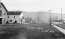
| Date: | 1921 |
|---|---|
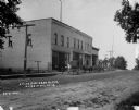
| Description: | View down Main Street. Osward's restaurant is on the far left. The post office and a plumbing shop are on the right. |

| Date: | |
|---|---|
| Description: | View down Main Street dirt road. A horse and buggy stand near a sidewalk on the left near a group of men. Further down on the right the Bangor State Bank h... |
If you didn't find the material you searched for, our Library Reference Staff can help.
Call our reference desk at 608-264-6535 or email us at: