 Filter: Categories of Wisconsin Historical Images
Filter: Subject of Roads
Filter: Type of Map or Atlas
Filter: Categories of Wisconsin Historical Images
Filter: Subject of Roads
Filter: Type of Map or Atlas

| Date: | 1994 |
|---|---|
| Description: | This brochure consists of a series of 16 maps of the Military Ridge State Park Trail and the Sugar River State Trail. In all, 62 miles of bike trails and 1... |
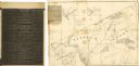
| Date: | 1838 |
|---|---|
| Description: | This map of the Wisconsin Territory, accompanied by the photostat of an article from the January 13, 1838, Wisconsin democrat, shows the area described as ... |

| Date: | 1949 |
|---|---|
| Description: | This color map includes historical descriptions of select areas and a short article on the history of Wisconsin. The major highways in the state shown on t... |

| Date: | 1923 |
|---|---|
| Description: | This map shows trails, some in red, for automobiles. The right margin includes a key of markings as well as Minnesota and Wisconsin Highway signs. Communit... |

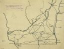
| Date: | 1844 |
|---|---|
| Description: | Part of a series of local maps, showing a number of burial mounds in the shape of animals near Madison, Wisconsin along military road. The maps also show d... |
| Date: | 1922 |
|---|---|
| Description: | An ink on tracing paper, hand-drawn of south and eastern Wisconsin, illustrating the roads ranging from Dubuque, Iowa in the east to Green Bay, Wisconsin i... |

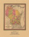
| Date: | 1895 |
|---|---|
| Description: | A map of Wisconsin that shows the counties, cities, towns, rivers, and lakes of the state, the eastern most portions of Minnesota, Iowa, northern Illinois,... |

| Date: | 1897 |
|---|---|
| Description: | A map of Wisconsin showing the self-supporting churches, Home Missionary churches, stations not organized, Sunday schools of C.S.S. Society, Congregational... |

| Date: | 1896 |
|---|---|
| Description: | A map showing the Wisconsin Central Railroad lines in Wisconsin, northern Illinois, eastern Minnesota, and Michigan’s Upper Peninsula. The area of the map ... |

| Date: | 1900 |
|---|---|
| Description: | A map of Wisconsin, eastern Minnesota and Iowa, northern Iowa, and Michigan’s Upper Peninsula, showing railway lines, with those marked with heavy red line... |

| Date: | 1900 |
|---|---|
| Description: | This map, which shows the state of Wisconsin in 1895, was published as Rand, McNally & Co.'s New business atlas map of Wisconsin. Railroads, counties, citi... |

| Date: | 1900 |
|---|---|
| Description: | A map of Wisconsin, eastern Minnesota and Iowa, and Michigan’s Upper Peninsula, showing the rail lines of the Wisconsin Central Railroad are shown in red, ... |

| Date: | 1915 |
|---|---|
| Description: | A map of Wisconsin that shows 1,900 miles of national highways proposed for the state. The map also includes the names and locations of towns and cities th... |

| Date: | 1933 |
|---|---|
| Description: | A road map of Wisconsin and Michigan’s Upper Peninsula, showing the populations of cities and villages, state and federal highways, national forests, state... |

| Date: | 1950 |
|---|---|
| Description: | A map from the Wisconsin identifying the locations airports and other landing facilities in the state. On the opposite side the map includes an alphabetica... |

| Date: | 1943 |
|---|---|
| Description: | A map that shows the lands for sale by the Tomahawk Land Company of Tomahawk, Wisconsin, in the counties of Langlade, Lincoln, Oneida, and Price. The map s... |

| Date: | 1850 |
|---|---|
| Description: | A hand-colored map showing portions of present-day Iron and Vilas counties north of the Manitowish River as part of the Upper Peninsula of Michigan. The Wi... |
| Date: | 1974 |
|---|---|
| Description: | A map that was originally published around 1851 in S. Augustus Mitchell's New universal atlas, shows portions of present-day Iron and Vilas counties north ... |

| Date: | 1851 |
|---|---|
| Description: | Map exhaustively marks the townships, County Towns and villages of Wisconsin. It also shows rivers, canals, railroads, and plank roads. Each county's popul... |

| Date: | 1853 |
|---|---|
| Description: | Wisconsin counties by color and shows railroads, common roads, canals, the state capital, county towns, townships, villages, and post offices, |
If you didn't find the material you searched for, our Library Reference Staff can help.
Call our reference desk at 608-264-6535 or email us at: