 Filter: Categories of Wisconsin Historical Images
Filter: Subject of Roads
Filter: Type of Map or Atlas
Filter: Categories of Wisconsin Historical Images
Filter: Subject of Roads
Filter: Type of Map or Atlas

| Date: | 1913 |
|---|---|
| Description: | Wisconsin map showing fifteen hundred miles of national highways proposed by the National Highways Association. Scale: 1:2,500,000. These highways will dir... |

| Date: | 1852 |
|---|---|
| Description: | Map reads: "The State of Wisconsin- compiled from the latest authorities". In addition, there is a scale which is six miles for every inch, and a profile o... |

| Date: | 1878 |
|---|---|
| Description: | Map reads: "The P.P. Mast & Co's New Map of Wisconsin, Minnesota, and Northern Iowa". There are various advertisements for P.P. Mast & Co's broad-cast seed... |
| Date: | 1849 |
|---|---|
| Description: | Map reads, "Map of the Western States". Published by Ensign & Thayer. There is a decorative vine border, and in each corner there is an engraving of four c... |

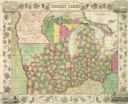
| Date: | 1854 |
|---|---|
| Description: | Map reads, "Map of Wisconsin". The map includes the counties, an inset of the city of Milwaukee, total population of each county and of the state. The scal... |
| Date: | 04 22 1915 |
|---|---|
| Description: | Topographical survey of a McCormick family property in Lake Forest, Illinois. The survey was completed for Anita McCormick [Mrs. Emmons] Blaine. The survey... |

| Date: | 1861 |
|---|---|
| Description: | A map of Wisconsin showing cities, counties, major roads, railroads, and bodies of water. Includes an inset of the vicinity of Milwaukee. |
| Date: | 1896 |
|---|---|
| Description: | Section 1 of 12, this bicycle road map features Wisconsin bicycle routes in the counties of Dane, Jefferson, Waukesha, Milwaukee, Green, Rock, Walworth, Ra... |

| Date: | 1876 |
|---|---|
| Description: | Map of home and land, with the roads, lakes, railroad, and buildings. |

| Date: | 1937 |
|---|---|
| Description: | Official state highway map, with insets of cities. |

| Date: | 1932 |
|---|---|
| Description: | This map includes a distance table, text, and insets maps of, Superior, Ashland, Marinette, Green Bay, Appleton, Manitowoc, Oshkosh, Fond Du Lac, Janesvill... |

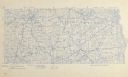
| Date: | 09 1854 |
|---|---|
| Description: | A map of government roads in Minnesota. |

| Date: | 1915 |
|---|---|
| Description: | Plat map of Polk township in Washington County. |

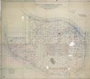
| Date: | 1959 |
|---|---|
| Description: | University of Wisconsin-Madison campus. Numbers in circles identify buildings across campus with the building index. Black arrows point out important infor... |
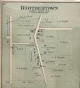
| Date: | 1893 |
|---|---|
| Description: | Plat map of Brothertown in Calumet County. |

| Date: | 1873 |
|---|---|
| Description: | Color outline map of Dane County, Wisconsin. |

| Date: | 1915 |
|---|---|
| Description: | Plat map of South Germantown in the Township of Germantown sections, 18,19 and 20 from Plat Book of Washington and Ozaukee Counties. |

| Date: | 1855 |
|---|---|
| Description: | Map of Milwaukee, Waukesha, Racine, and Kenosha Counties with part of Walworth County showing townships, waterways, railroads, plank roads, prairies, meado... |

| Date: | 1896 |
|---|---|
| Description: | Section 2 of 12, this bicycle road map features Wisconsin bicycle routes in the counties of Marquette, Green Lake, Columbia, Fond Du Lac, Dodge, Washington... |
If you didn't find the material you searched for, our Library Reference Staff can help.
Call our reference desk at 608-264-6535 or email us at:
