 Filter: Categories of Wisconsin Historical Images
Filter: Subject of Roads
Filter: Type of Map or Atlas
Filter: County of Brown
Filter: Categories of Wisconsin Historical Images
Filter: Subject of Roads
Filter: Type of Map or Atlas
Filter: County of Brown

| Date: | 1908 |
|---|---|
| Description: | This 1908 map shows the township and range grid, sections, towns, villages, railroads, bridges, lakes, streams, rapids, and state-owned lands in Oneida Cou... |

| Date: | 1959 |
|---|---|
| Description: | This map identifies public forest land and industrial forest land as of 1959 in Oneida County, Wisconsin, using a 1930 base map showing the township and ra... |

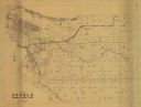
| Date: | 1836 |
|---|---|
| Description: | This manuscript shows the 1835 survey of the road corresponding approximately to a portion of County Trunk A in the Town of Scott, Brown County, Wisconsin.... |

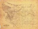
| Date: | 1870 |
|---|---|
| Description: | This 1870 map of Brown County, Wisconsin, shows the township and range grid, towns, sections, cities, villages and post offices, land ownership, roads, rai... |

| Date: | 1896 |
|---|---|
| Description: | This map of Brown County, Wisconsin, from the late 19th century shows land claims along the Fox River, the township and range grid, towns, sections, cities... |
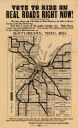
| Date: | 1919 |
|---|---|
| Description: | This flier, likely printed in 1919, promotes the vote for a bond issue to fund "hard roads" in Brown County, Wisconsin. The map shows the 135 miles of conc... |

| Date: | 1903 |
|---|---|
| Description: | Map of Brown County, Wisconsin, shows the township and range grid, towns, sections, cities, villages and post offices, land owners and acreages, railroads,... |
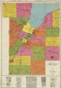
| Date: | 1930 |
|---|---|
| Description: | This early-mid 20th century map of Brown County, Wisconsin, shows the township and range grid, towns, sections, cities and villages, land owners and acreag... |

| Date: | 1961 |
|---|---|
| Description: | Map of the Town of Preble, Brown County, Wisconsin, showing land ownership by name, subdivisions, roads and streets, railroads, and local businesses. |

| Date: | 1893 |
|---|---|
| Description: | Bird’s-eye view of Depere looking North. Includes illustrations and an index to points of interest. |

| Date: | 08 27 1825 |
|---|---|
| Description: | Map is ink on paper. Map shows plat of the town of Munnomunne, the Fox River, farm lots, and an established highway. The map is signed by "J.D. Doty, Propr... |

| Date: | 1974 |
|---|---|
| Description: | This map shows roads, highways, railroads, major arterials, towns, parks, recreational areas, and parts of Fox River and bay of Green Bay. The map includes... |

| Date: | 1868 |
|---|---|
| Description: | This map shows land ownership by name, lots, roads, railroads, and part of the Fox River. The map includes an explanation and table of witnesses to the cor... |

| Date: | 1987 |
|---|---|
| Description: | This map pictorially shows local roads, local businesses with phone numbers, and parts of Fox River and bay of Green Bay. |

| Date: | 1950 |
|---|---|
| Description: | This map shows portions of highway remaining unchanged, proposed relocations, connecting county trunk roads existing or proposed, existing arterials, and e... |

| Date: | 1800 |
|---|---|
| Description: | This map shows plat of the town, local streets, plank roads, and part of the Fox River. The bottom of the map includes annotations, probably in pencil. |
| Date: | 1935 |
|---|---|
| Description: | This map is a photocopy and shows landownership and acreages, additions to Green Bay, points of interest, roads, and railroads. Hand annotations of green,... |
| Date: | 01 1935 |
|---|---|
| Description: | This map shows landownership and acreages, additions to Green Bay, roads, railroads, East River, and Fox River. The bottom left of the map reads: "January ... |

| Date: | 1900 |
|---|---|
| Description: | This photostat map shows private claim owners, natural meadows, roads, saw and grist mills, and Fort Howard. The upper right corner includes annotations an... |

| Date: | 1900 |
|---|---|
| Description: | This photostat map was probably originally created in 1835 and shows in addition to private claims, mills, roads, and trails. Green Bay and the Fox River a... |
If you didn't find the material you searched for, our Library Reference Staff can help.
Call our reference desk at 608-264-6535 or email us at: