 Filter: Categories of Wisconsin Historical Images
Filter: Subject of Road construction industry
Filter: County of Milwaukee
Filter: Creator Name of Unknown
Filter: Categories of Wisconsin Historical Images
Filter: Subject of Road construction industry
Filter: County of Milwaukee
Filter: Creator Name of Unknown
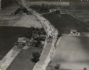
| Date: | 1935 |
|---|---|
| Description: | Aerial view of the paving operation of Joseph D. Bonners, Inc., on St. Martins Road at Hales Corners. |
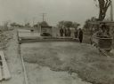
| Date: | 1920 |
|---|---|
| Description: | Workers and inspectors of a mechanized concrete pour somewhere in Milwaukee County. By 1920 Milwaukee was famous for its 18-foot wide concrete roads, the c... |

| Date: | 1965 |
|---|---|
| Description: | Aerial view of early construction at the Marquette Interchange in Milwaukee, the junction of Interstate Highways I94 and I43. Construction began in 1964, ... |
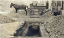
| Date: | 10 1914 |
|---|---|
| Description: | Buffalo Street construction showing cuts in the pavement and the inconvenience for traffic. Standing between the excavated holes and piles of dirt is a hor... |
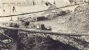
| Date: | 10 1914 |
|---|---|
| Description: | Buffalo Street construction, showing heating pipes being installed under the cut pavement. A boy is bent over in near a pile of dirt in the background look... |

| Date: | 1976 |
|---|---|
| Description: | An 1876 reprinted map of the Township of Franklin, Milwaukee County, Wisconsin, that shows the land ownership and sectioning of the town, as well as the ro... |
If you didn't find the material you searched for, our Library Reference Staff can help.
Call our reference desk at 608-264-6535 or email us at: