 Filter: Categories of Wisconsin Historical Images
Filter: Subject of Rivers
Filter: Year of 2000-Present
Filter: Categories of Wisconsin Historical Images
Filter: Subject of Rivers
Filter: Year of 2000-Present

| Date: | 2007 |
|---|---|
| Description: | This map of Cedarbug is a bird's-eye map with 8 inset views and an index. The map is a print out of the original map dated 1892 held at the Cedarburg Cultu... |

| Date: | 2013 |
|---|---|
| Description: | Map is the most extensive endeavor to date to accurately locate and document both prehistoric place names and natural features of the Menominee language wi... |

| Date: | 07 2003 |
|---|---|
| Description: | This Barton dam is the subject of a photo study. Anna Williams acts as a model. |
| Date: | 2000 |
|---|---|
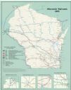
| Description: | This map shows railroads by operating freight and government agencies, Amtrak stations, ports, rail lines out of service, rail banks, and Rails-to-Trails. ... |

| Date: | 2003 |
|---|---|
| Description: | The front of map shows trails throughout the bottom half of Wisconsin and includes text on snowmobile rules and tourism contacts. The reverse shows trails ... |
| Date: | 2012 |
|---|---|
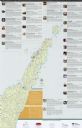
| Description: | This map includes a descriptive index of galleries and studios with color illustrations, on both sides. |

| Date: | 2000 |
|---|---|
| Description: | This map shows Wisconsin Public Service Corporation property, special regulation areas, public boat landings, roads, parks, and other recreation areas. Ins... |
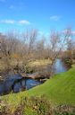
| Date: | 11 2013 |
|---|---|
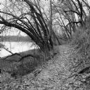
| Description: | View down a small dirt path lined with grasses and trees along Ferry Bluff State Natural Area. To the left is Honey Creek leading to the Wisconsin River. |

| Date: | 2000 |
|---|---|
| Description: | This map shows the industrial area along the Menominee River and canals. Industrial buildings are shown in orange and labeled in red. Other areas are shown... |

| Date: | 2005 |
|---|---|
| Description: | This map shows dams and falls, areas of portage, canoe and kayak access, boat launches, parking, restrooms, picnic areas, dining, rapid water, parks, and b... |
| Date: | 03 2014 |
|---|---|
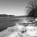
| Description: | View looking down slope towards ice floes drifting down the Rock River. The steel frame of a dock protrudes from the shoreline on the left, which has a cov... |
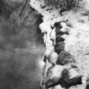
| Date: | 03 2014 |
|---|---|
| Description: | View looking down at the bank of the Yahara River. The sun is being reflected in the water near the snow covered stones on the shoreline. |
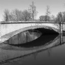
| Date: | 05 2014 |
|---|---|
| Description: | View across water towards the weathered footbridge spanning the Tenney Park lagoon near Marston Avenue. The word "Marston" is carved into the side of the b... |
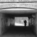
| Date: | 05 2014 |
|---|---|
| Description: | Silhouette of a person riding a bicycle through a pedestrian tunnel under East Johnson Street near the Yahara River and Tenney Park. Above the entrance to ... |
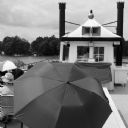
| Date: | 07 2014 |
|---|---|
| Description: | View from back of river boat on a tour of a river. People are sitting on benches wearing hats and holding up umbrellas. A man is piloting the boat from a s... |
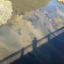
| Date: | 09 18 2014 |
|---|---|
| Description: | View from a bridge looking down at the shadow of the photographer on the surface of the Sugar River. |
| Date: | 10 28 2014 |
|---|---|
| Description: | View looking down towards a green lawn along a riverbank. Extending out from the shoreline is a tree with a long horizontal trunk extending into the Sugar ... |
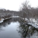
| Date: | 11 27 2014 |
|---|---|
| Description: | Slightly elevated view of snow-covered trees lining both banks of the Kishwaukee River. In the distance the river is bending to the right. The ground is co... |
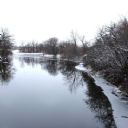
| Date: | 11 27 2014 |
|---|---|
| Description: | Slightly elevated view of trees along the banks of the Kishwaukee River. Snow is on the ground and tree branches. Ice is along the shoreline on the right. |

| Date: | 08 01 2015 |
|---|---|
| Description: | Group portrait of three men and a woman, all wearing sunglasses. The two younger men are wearing baseball hats, and the woman is wearing a blue scarf. Behi... |
If you didn't find the material you searched for, our Library Reference Staff can help.
Call our reference desk at 608-264-6535 or email us at: