 Filter: Categories of Wisconsin Historical Images
Filter: Subject of Rivers
Filter: Categories of Wisconsin Historical Images
Filter: Subject of Rivers
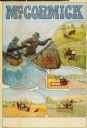
| Date: | 1915 |
|---|---|
| Description: | Advertising poster for McCormick brand farm implements featuring two men paddling a canoe in rough water. Also includes color illustrations of a reaper, ha... |
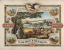
| Date: | 1876 |
|---|---|
| Description: | Color chromolithograph illustration advertising poster for the Marsh Harvester, produced by Gammon and Deering Company. Printed by Charles Shober & Co., Ch... |
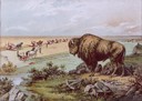
| Date: | 1889 |
|---|---|
| Description: | Color lithograph illustration on the back cover of the McCormick Harvesting Machine Company catalog. Shows a buffalo gazing down upon men with harvesting m... |

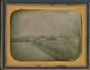
| Date: | 1855 |
|---|---|
| Description: | Quarter plate daguerreotype of the Oshkosh harbor, showing the bridge over the Fox River and several moored sailing vessels. |
| Date: | 1855 |
|---|---|
| Description: | Half plate daguerreotype, with view across water of the Oshkosh, Wisconsin harbor showing the bridge over the Fox River. Moored on the opposite shore are t... |

| Date: | 1834 |
|---|---|
| Description: | Peck-a-ton-oka (Pecatonica River) with Rodolf farm in the background. |

| Date: | 1744 |
|---|---|
| Description: | A map of a plan of 16,500 acres of land. |
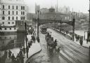
| Date: | 1904 |
|---|---|
| Description: | Elevated view of wagons hauling coal from the Milwaukee Western Fuel Company holding up street car traffic on a busy Milwaukee street. |

| Date: | 1850 |
|---|---|
| Description: | Painting depicting Chippewa Falls and the first sawmill on the Chippewa River, built by Jean Brunet. The residence of H.S. Allen, one of the owners of the... |
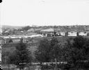
| Date: | |
|---|---|
| Description: | Elevated view from south side of the Chippewa River, with a bridge crossing it and buildings on both sides of the river. A bluff rises on the far side of t... |

| Date: | 1803 |
|---|---|
| Description: | Cours du Mississippi : comprenant la Louisiane, les 2 Florides, une partie des Etats-Unis, et pays adjacents. |

| Date: | 1821 |
|---|---|
| Description: | Engraving depicting the Schoolcraft expedition crossing the Ontonagon River to investigate a copper boulder. |
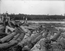
| Date: | 1903 |
|---|---|
| Description: | Three barefoot boys stand on a pile of logs in the foreground looking across the river at a group of men working to free a log jam in the Big Eddy on the C... |

| Date: | 1873 |
|---|---|
| Description: | Map of the township of Windsor, from the "Atlas of Dane County." |
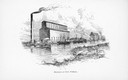
| Date: | |
|---|---|
| Description: | Illustration of exterior view of elevators at Fort William. |

| Date: | 1848 |
|---|---|
| Description: | In 1849, northern Wisconsin was composed of huge sectional regions such as Chippewa, Portage, Brown and Crawford, whereas southern Wisconsin was constitute... |
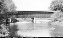
| Date: | 1940 |
|---|---|
| Description: | Exterior view of the last covered bridge in Wisconsin. Caption reads: "Covered Bridge Near Cedarburg, Wis." |

| Date: | 1697 |
|---|---|
| Description: | Father Hennepin's map in French of the upper lakes. |
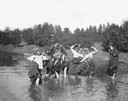
| Date: | |
|---|---|
| Description: | Group of women in comical poses pulling up their skirts while standing in a stream. One woman stands on the river bank on the right. Behind them is a hill... |
If you didn't find the material you searched for, our Library Reference Staff can help.
Call our reference desk at 608-264-6535 or email us at:
