Filter: Categories of Wisconsin Historical Images
Filter: Subject of Rivers
Filter: Year of 1900-1999
Filter: County of Ozaukee
Filter: Categories of Wisconsin Historical Images
Filter: Subject of Rivers
Filter: Year of 1900-1999
Filter: County of Ozaukee
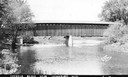
| Date: | 1940 |
|---|---|
| Description: | Exterior view of the last covered bridge in Wisconsin. Caption reads: "Covered Bridge Near Cedarburg, Wis." |
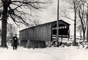
| Date: | 1934 |
|---|---|
| Description: | Southwest view of a covered bridge over Cedar Creek, with a man walking in the snow nearby. |
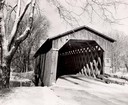
| Date: | 1957 |
|---|---|
| Description: | Covered bridge over Cedar Creek in Ozaukee County on highway, about one mile north of Cedarburg. The last remaining covered bridge in Wisconsin. Snow is on... |
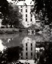
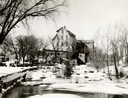
| Date: | 1950 |
|---|---|
| Description: | The Thiensville Mill as seen from the waterfront. |
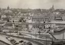
| Date: | 1952 |
|---|---|
| Description: | An elevated view of the downtown section. |
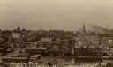
| Date: | 1909 |
|---|---|
| Description: | Elevated view of town. Caption reads: "Birdseye View Port Washington, Wis." |

| Date: | 1960 |
|---|---|
| Description: | This blue line print map shows zone districts, lot and block numbers and dimensions, building setbacks, center lines of streets, and some landownership. Th... |

| Date: | 1906 |
|---|---|
| Description: | Elevated view of the Cedarburg skyline from a bridge over Cedar Creek. There are dwellings in the foreground. Caption reads: "Looking North from Bridge, Ce... |
| Date: | 1918 |
|---|---|
| Description: | View of Grafton from across a dam on the Milwaukee River. St. Joseph's Catholic Church is in the distance on a hill. Caption reads: "Scenic View, Grafton, ... |
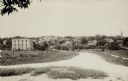
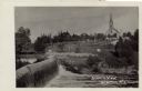
| Date: | 1916 |
|---|---|
| Description: | View of Grafton from the road leading into town. There is a bridge over the river, and a church is on the far right. Caption reads: "Birdseye [sic] View, G... |

| Date: | 06 1969 |
|---|---|
| Description: | The Cedarburg Bridge, originally known as the Red Bridge, with a flowering tree on the right. Originally Wisconsin had more than 40 covered bridges. This i... |

| Date: | 1921 |
|---|---|
| Description: | A plat map of Mequon, Wisconsin. Text at top reads: "T. 9N. R.21 E MEQUON T. 9N. R.22 E." |

| Date: | 1915 |
|---|---|
| Description: | A composite plat map of the towns of Mequon, Saukville, Belgium, Fort Washington, and Fredonia. |
If you didn't find the material you searched for, our Library Reference Staff can help.
Call our reference desk at 608-264-6535 or email us at: