Filter: Categories of Wisconsin Historical Images
Filter: Subject of Rivers
Filter: Year of 1900-1999
Filter: County of Marathon
Filter: Categories of Wisconsin Historical Images
Filter: Subject of Rivers
Filter: Year of 1900-1999
Filter: County of Marathon

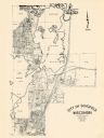
| Date: | 1943 |
|---|---|
| Description: | This photocopy map shows inhabited farms, rivers, roads, and mills in the vicinity of Marathon City [and village of Edgar], including area between the Big ... |
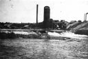
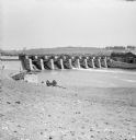
| Date: | 1900 |
|---|---|
| Description: | View of the Wausau mill and dam next to the river, where logs were first sorted. |
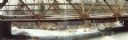
| Date: | 1905 |
|---|---|
| Description: | Elevated view toward the lumber company. A bridge over a river is in the foreground. Caption reads: "Looking South from City Hall Tower, Wausau, Wis." |
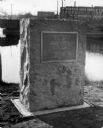
| Date: | 1929 |
|---|---|
| Description: | View of the George Stevens marker with the Wisconsin Auto Supply Company in the background and the Wisconsin River. |
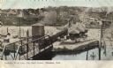
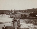
| Date: | 1905 |
|---|---|
| Description: | Elevated view of the railroad station looking west. A bridge over the river is in the foreground, and a large water tower is across the railroad tracks on ... |
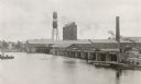
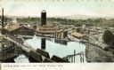
| Date: | 1915 |
|---|---|
| Description: | Elevated view of the Marathon Paper Mills from across the river. Caption reads: "Scene at the Marathon Paper Mills, Wausau, Wis." |

| Date: | 11 30 1989 |
|---|---|
| Description: | Panoramic view of the bridge over the frozen Eau Claire River. |

| Date: | 1936 |
|---|---|
| Description: | Two women sitting on top of rocks in the Dells of the Eau Claire River. There is a bridge in the background on the left. |
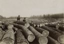
| Date: | 1900 |
|---|---|
| Description: | Two women and one man in street clothes and wearing hats posing among the logs of a large log jam on the Wisconsin River. |

| Date: | 1965 |
|---|---|
| Description: | Map shows original plat, plat additions, and lot measurements for Rothschild, Wisconsin. Lake Wausau and the Wisconsin River are labelled. Map reads: "Comp... |
| Date: | 1965 |
|---|---|
| Description: | This map shows lot and block numbers and dimensions, additions, streets, and railroads. |

| Date: | 1919 |
|---|---|
| Description: | Dr. Joseph Smith and his wife, Mary, pose next to trees by a rivers edge. |

| Date: | 1919 |
|---|---|
| Description: | Dr. Joseph Smith poses with friends next to a tree along a rivers edge. |

| Date: | 1913 |
|---|---|
| Description: | Elevated view of man seated on cliffs edge overlooking the dells of the Eau Claire River. Farther upstream is a bridge over the river. |

| Date: | 1913 |
|---|---|
| Description: | Elevated view of the Eau Claire River rushing over large rocky formations. A bridge crosses over the river on the left. Large tree trunks have been stacked... |

| Date: | 1913 |
|---|---|
| Description: | View up river towards a bridge over a rocky portion of the Eau Claire River. A women is standing on rocks beneath the bridge in the center, while a man sta... |
| Date: | 1913 |
|---|---|
| Description: | View down riverbank towards dam of a river around Wausau. Two men and a limber (two-wheeled cart) are near the rivers edge. A man, perhaps a construction w... |
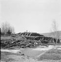
| Date: | 1913 |
|---|---|
| Description: | View from low hill of piles of logs along the icy rivers edge. A pile of logs is on the shoreline, and a large amount of neatly stacked logs are in the bac... |
If you didn't find the material you searched for, our Library Reference Staff can help.
Call our reference desk at 608-264-6535 or email us at: