 Filter: Categories of Wisconsin Historical Images
Filter: Subject of Rivers
Filter: Year of 1900-1999
Filter: Creator Name of Vinje, Arthur M., 1888-1972
Filter: Categories of Wisconsin Historical Images
Filter: Subject of Rivers
Filter: Year of 1900-1999
Filter: Creator Name of Vinje, Arthur M., 1888-1972
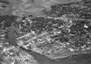
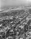
| Date: | 11 1928 |
|---|---|
| Description: | Aerial view of Stoughton including the central business district, the Yahara River, and the surrounding countryside. |
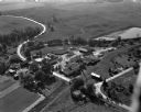
| Date: | 1934 |
|---|---|
| Description: | Aerial view of the Jones dairy farm, Fort Atkinson, in winter. The Rock River is in the background. |

| Date: | 11 1928 |
|---|---|
| Description: | Aerial view of Stoughton, including the central business district, residential areas, the Yahara River, and the surrounding countryside. |

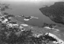
| Date: | 1930 |
|---|---|
| Description: | Aerial view of Tenney Park, including the lagoon, residences surrounding the park, and the shoreline of Lake Mendota on bottom left. |
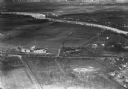
| Date: | 1930 |
|---|---|
| Description: | Aerial view of Lake Delton, the Wisconsin River, and the surrounding countryside. |
| Date: | 02 23 1953 |
|---|---|
| Description: | University of Wisconsin varsity crew in a practice boat on the Yahara River. View looking south with Westinghouse Electric Supply Company, 110 North Thorn... |
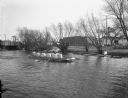
| Date: | 02 23 1953 |
|---|---|
| Description: | University of Wisconsin crew rowing down the Yahara River. View looking south toward railroad bridge in the 100 block of North Thornton Avenue. |
| Date: | 02 23 1953 |
|---|---|
| Description: | University of Wisconsin crew gets into their shell from the dock on the Yahara River with Trachte boat houses in the background. View looking northwest tow... |

| Date: | 06 18 1945 |
|---|---|
| Description: | Four people fishing from the Westport bridge. Six people have lost their lives within the past eight weeks at this bridge. |
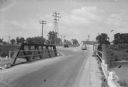
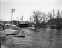
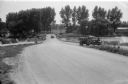
| Date: | 08 07 1945 |
|---|---|
| Description: | State Highway 113 bridge over the Yahara River in Westport. The photograph is taken from the south end of the bridge showing the highway going straight ahe... |
| Date: | 08 07 1945 |
|---|---|
| Description: | State Highway 113 bridge over the Yahara River in Westport. The photograph is taken from the north end of the bridge showing the "blind" curve on the immed... |
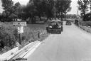
| Date: | 08 07 1945 |
|---|---|
| Description: | State Highway 113 bridge over the Yahara River in Westport, with two automobiles and road signs that read: "County Highway M, Middleton 7 miles"; "State Hi... |
| Date: | 09 10 1947 |
|---|---|
| Description: | Aerial view of the River View Cannery. |
| Date: | 01 22 1949 |
|---|---|
| Description: | Aerial photograph of the city of Fort Atkinson. |

| Date: | 03 16 1949 |
|---|---|
| Description: | Aerial view of Mauston, Wisconsin. |
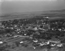
| Date: | 04 21 1949 |
|---|---|
| Description: | Aerial view of Spring Green. Houses and commercial buildings are in the foreground and a rural area is in the background. Hills are in the distance. |
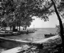
| Date: | 07 22 1949 |
|---|---|
| Description: | Tenney Park breakwater and Lake Mendota. The city of Madison was able to resume construction at no cost. The construction company tearing up East Washingto... |
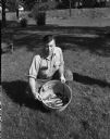
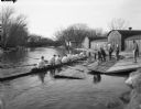
| Date: | 09 20 1949 |
|---|---|
| Description: | Al Koppenhaver, a game warden for the Wisconsin Department of Natural Resources, holding a bucket of dead fish that were removed from the Yahara River belo... |
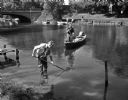
| Date: | 09 20 1949 |
|---|---|
| Description: | Two Wisconsin Department of Natural Resources employees removing dead fish from the Yahara River near the Johnson Street bridge. The fish were evidently ki... |

| Date: | 12 16 1949 |
|---|---|
| Description: | Scene along the Yahara River where the body of Max Hobert, a Madison bartender, was found. |
If you didn't find the material you searched for, our Library Reference Staff can help.
Call our reference desk at 608-264-6535 or email us at: