 Filter: Categories of Wisconsin Historical Images
Filter: Subject of Rivers
Filter: Year of 1800-1899
Filter: Categories of Wisconsin Historical Images
Filter: Subject of Rivers
Filter: Year of 1800-1899
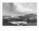
| Date: | 1832 |
|---|---|
| Description: | Herd of Bison, on the Upper Missouri River. |
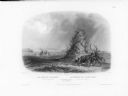
| Date: | 1832 |
|---|---|
| Description: | The Elkhorn Pyramid, on the Upper Missouri River. Passing Indians would add horns to the pyramid, and sometimes add red marks to the horns to indicate the ... |
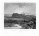
| Date: | 1832 |
|---|---|
| Description: | The White Castles, on the Upper Missouri River. |
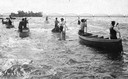
| Date: | 07 16 1898 |
|---|---|
| Description: | A group of Ojibwa men fishing from boats. |

| Date: | 1862 |
|---|---|
| Description: | Drawn the second year of the Civil War, this 1862 map of Milwaukee shows post offices, light houses, beacon lights, county buildings, elevator warehouses, ... |
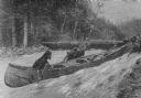
| Date: | 03 1892 |
|---|---|
| Description: | Three men are dragging their canoe upriver through a strong current. In the background other men are standing on the far river bank near canoes pulled up o... |
| Date: | 1879 |
|---|---|
| Description: | Lithograph of voyageurs making a portage from an article on "The Honorable Hudson Bay Company" from Harpers Monthly in 1879. |

| Date: | 1890 |
|---|---|
| Description: | Portion of the plat map of the north part of Caledonia in Columbia County, including explanations. |

| Date: | 1890 |
|---|---|
| Description: | Plat map of the south part of Caledonia in Columbia County. |

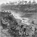
| Date: | 02 21 1874 |
|---|---|
| Description: | African American boatmen run a rapids in a small river boat. |
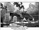
| Date: | 1867 |
|---|---|
| Description: | Engraving of the McCormick Reaper Works as it appeared in 1867. The factory was located on the north bank of the Chicago River, east of the Rush Street bri... |
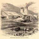
| Date: | 05 1866 |
|---|---|
| Description: | Engraved exterior view of a smelting furnace with a small group of men with horses gathered in front. |
| Date: | 1884 |
|---|---|
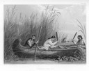
| Description: | Three women in a canoe harvest wild rice. |

| Date: | 1876 |
|---|---|
| Description: | Bird's-eye view of Black Earth. |

| Date: | 1867 |
|---|---|
| Description: | Birds-eye drawing of Appleton, Outagamie Co., depicting street names and street layout, houses, the Fox River, the court house, jail, school houses, Lawren... |
| Date: | 1895 |
|---|---|
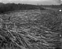
| Description: | Logs move down the river, swirling with cross currents, resulting in a huge log jam. |

| Date: | 1839 |
|---|---|
| Description: | This map shows the hydrology of Madison and its vicinity at the height of interest in a proposed Milwaukee and Rock River Canal. It was made by Thomas Jeff... |

| Date: | 1839 |
|---|---|
| Description: | A map of the Wiskonsin [sic] and Neenah or Fox Rivers. |

| Date: | 1832 |
|---|---|
| Description: | Hand-drawn map in two parts of the route of Governor J.D. Doty. Probably made by Doty in 1832 as a result of his travels with Alexander J. Center. |

| Date: | 1870 |
|---|---|
| Description: | Baraboo was first settled around 1838, and by 1870 it had become the county seat and the thriving village illustrated here. This birds eye drawing depicts ... |
If you didn't find the material you searched for, our Library Reference Staff can help.
Call our reference desk at 608-264-6535 or email us at: