 Filter: Categories of Wisconsin Historical Images
Filter: Subject of Rivers
Filter: Year of 1800-1899
Filter: Year of 1850-1859
Filter: Categories of Wisconsin Historical Images
Filter: Subject of Rivers
Filter: Year of 1800-1899
Filter: Year of 1850-1859

| Date: | 1856 |
|---|---|
| Description: | This map shows the railroad routes that lead to Milwaukee. Included are portions of Minnesota, Iowa and Illinois. Lake Michigan is on the right, while Lake... |
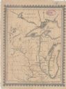
| Date: | 1856 |
|---|---|
| Description: | This map shows township grids, existing settlements, Indian reservations, rivers, lakes, and treaty lines. Included is a portion of Minnesota. Lake Michiga... |

| Date: | 1857 |
|---|---|
| Description: | This map shows the railroad routes of the Milwaukee & Horicon Railroad, common roads, counties, canals, townships, cities, county towns, villages, post off... |

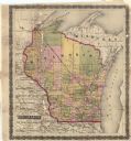
| Date: | 1857 |
|---|---|
| Description: | This map shows county boundaries, larger cities, lakes, rivers, and the railroad network. The main line is in red, and the Milwaukee and Chicago Railroad i... |
| Date: | 1857 |
|---|---|
| Description: | This map shows drainage, state boundaries, county boundaries, rivers, lakes, township lines, cities, and towns. The Milwaukee & Horicon Road road is indica... |
| Date: | 1855 |
|---|---|
| Description: | This map shows railroad lines from Chicago, with emphasis on the proposed railroad from Chicago to Madison to Lake Superior near the Ontonagon River. Inclu... |

| Date: | 1850 |
|---|---|
| Description: | This map shows the location of planned blocks and lot numbers, street names, and docks along the Fox River and canal. |

| Date: | 1850 |
|---|---|
| Description: | This photocopied map shows lot and block numbers, selected buildings, street names and state lock located on the Fox River. Includes a description of Deper... |

| Date: | 1855 |
|---|---|
| Description: | This map shows the Fox River, Lake Winnebago, streets, and plats. Below the title reads: "N. F.&Co. will make surveys of lands and plat the same in the bes... |
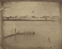
| Date: | 1851 |
|---|---|
| Description: | A rare photograph of U.S. Army soldiers stationed at Fort Howard rowing a boat on the Fox River. Fort Howard, built in 1816, was the first in the chain of ... |

| Date: | 1854 |
|---|---|
| Description: | A sketch of the public surveys of Wisconsin and territory of Minnesota. |
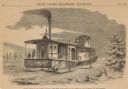
| Date: | 1859 |
|---|---|
| Description: | Engraved drawing of Norman Wiard's ice locomotive, the Lady Franklin operating on a frozen river. Male passengers and crew members are standing on t... |
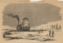
| Date: | 1859 |
|---|---|
| Description: | Engraved drawing of Norman Wiard's ice locomotive, Lady Franklin being pulled from water onto ice using its anchor. The vessel was built, but never ... |
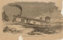
| Date: | 1859 |
|---|---|
| Description: | Engraved drawing of Norman Wiard's ice locomotive, Lady Franklin leaving a snowy riverbank and entering the frozen river. The vessel was built, but ... |
| Date: | 1850 |
|---|---|
| Description: | Text on front reads: "Racine, Wisconsin in 1850." Artist's rendering of the view of the harbor with sailing ships, sailboats, rowboats and canoes. The Main... |

| Date: | 1857 |
|---|---|
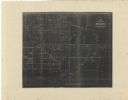
| Description: | Green Lake County Abstract plat map, T. 14 N, R. 11 E. |

| Date: | 1857 |
|---|---|
| Description: | Green Lake County abstract plat map, T. 16 N, R. 11 E. |

| Date: | 1857 |
|---|---|
| Description: | Green Lake County plat map, T. 15 N., R. 12 E. |

| Date: | 1857 |
|---|---|
| Description: | Green Lake County plat map, T. 14 N, R. 12 E. |

| Date: | 1857 |
|---|---|
| Description: | Green Lake County plat map, T. 16 N, R. 12 E. |
If you didn't find the material you searched for, our Library Reference Staff can help.
Call our reference desk at 608-264-6535 or email us at: