Filter: Categories of Wisconsin Historical Images
Filter: Subject of Rivers
Filter: Year of 1800-1899
Filter: Subject of land
Filter: Year of 1890-1899
Filter: Categories of Wisconsin Historical Images
Filter: Subject of Rivers
Filter: Year of 1800-1899
Filter: Subject of land
Filter: Year of 1890-1899

| Date: | 1890 |
|---|---|
| Description: | Portion of the plat map of the north part of Caledonia in Columbia County, including explanations. |

| Date: | 1890 |
|---|---|
| Description: | Plat map of the south part of Caledonia in Columbia County. |

| Date: | 1896 |
|---|---|
| Description: | Bird's-eye map of Darlington. Area bordered by Washington and North Streets, upper left hand corner, the fairgrounds, upper right corner, River Street, bot... |

| Date: | 1891 |
|---|---|
| Description: | Bird's-eye view of Eau Claire. |

| Date: | 1893 |
|---|---|
| Description: | Bird's-eye map of Jefferson, looking north. Crayfish River at left and center, Rock River from upper center to bottom center, joins at left of center; thir... |

| Date: | 1898 |
|---|---|
| Description: | Bird's-eye map, looking west from shoreline on Lake Michigan of Milwaukee to Golden Lake in Waukesha County, with Kenosha and Fox Point at bottom corners, ... |

| Date: | 1892 |
|---|---|
| Description: | Bird's-eye map of Princeton, with an inset of the Residence of F.T. Yahr. Fox River loops to left of center, with one bridge; thirty-six businesses, reside... |

| Date: | 1891 |
|---|---|
| Description: | Bird's-eye map of Stevens Point, looking east, with an inset of the Water Works. Wisconsin River in foreground with fifty-three business locations identifi... |
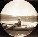
| Date: | 05 09 1894 |
|---|---|
| Description: | Reuben Gold Thwaites rowing the skiff the "Pilgrim" on the Ohio River. |

| Date: | 1892 |
|---|---|
| Description: | Bird's-eye view of Chicago, with ships in the Lake Michigan harbor. |

| Date: | 1892 |
|---|---|
| Description: | Bird's-eye view of the Columbian Exposition pavilions from the vantage point of Lake Michigan. Included is an inset of the Union Passenger Station (now Uni... |
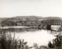
| Date: | 1893 |
|---|---|
| Description: | View from the south, with a railroad in the foreground, a river in the middle distance, and Janesville in the background. |

| Date: | 1895 |
|---|---|
| Description: | View of a mill, sluice and dam on Waumandee Creek. The mill was built by John Oschner in 1863. Two products produced by the mill were White Rose Flour and ... |
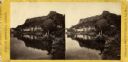
| Date: | 1890 |
|---|---|
| Description: | A stereograph of Trempealeau from the river. |

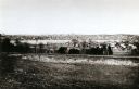
| Date: | 1898 |
|---|---|
| Description: | View from water tower, showing the grove where Black Hawk's pursuers were supposed to have camped in 1832. The group of men in the foreground are digging f... |
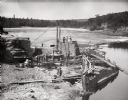
| Date: | 1895 |
|---|---|
| Description: | Elevated view of men in the midst of dam construction. |

| Date: | 1896 |
|---|---|
| Description: | Map showing the Wisconsin Central Railroad and its land grant, with the railroad and the land grant in color (red). |
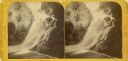
| Date: | 1890 |
|---|---|
| Description: | Stereograph of Big Manitou Falls on the Black River. This waterfall reportedly was called "Gitchee Monido" by the Ojibwa, which means "Falls of the Great S... |
If you didn't find the material you searched for, our Library Reference Staff can help.
Call our reference desk at 608-264-6535 or email us at: