 Filter: Categories of Wisconsin Historical Images
Filter: Subject of Rivers
Filter: Year of 1800-1899
Filter: County of Winnebago
Filter: Creator Name of Unknown
Filter: Categories of Wisconsin Historical Images
Filter: Subject of Rivers
Filter: Year of 1800-1899
Filter: County of Winnebago
Filter: Creator Name of Unknown

| Date: | 1855 |
|---|---|
| Description: | Quarter plate daguerreotype of the Oshkosh harbor, showing the bridge over the Fox River and several moored sailing vessels. |

| Date: | 1870 |
|---|---|
| Description: | The corner of unpaved Main Street and Tayco Street looking south towards Doty Island. The slanting timbers controlled the primitive draw bridge across the ... |
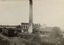
| Date: | 08 24 1888 |
|---|---|
| Description: | Slightly elevated view of the George A. Whiting Paper Mill after a fire on August 24, 1888. Sixteen men were killed by the explosion of a bleacher; the ble... |
| Date: | 1870 |
|---|---|
| Description: | Stereograph view of Cedar Street Bridge(?) with a rocky shoreline on the left. The construction of this bridge is the same as the Cedar Street bridge, but ... |
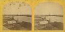
| Date: | 1870 |
|---|---|
| Description: | Stereograph of an elevated view of the lumbering industry on the Fox River. Lake Winnebago is in the background. |

| Date: | 1870 |
|---|---|
| Description: | Stereograph of a view along the Fox River. A pier with pilings is along the right, with industrial buildings. |
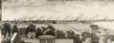
| Date: | 1880 |
|---|---|
| Description: | Illustration of an elevated view over rooftops looking towards Oshkosh. There are chimneys along the horizon with smoke rising into the sky. A river is alo... |

| Date: | 1870 |
|---|---|
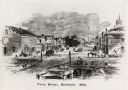
| Description: | Stereograph of an elevated view of the Main Street bridge, looking toward a section of the city known locally as Brooklyn. |

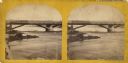
| Date: | 1856 |
|---|---|
| Description: | View along bridge of paddle boats and ships in the harbor, pedestrians, and the town in the background on the other side of the river. |
| Date: | 1856 |
|---|---|
| Description: | View from bridge on river. Storefronts and homes line the road that stretches to the horizon. |

| Date: | 1872 |
|---|---|
| Description: | Shows landowners, buildings, lot numbers, roads and railroads. Includes Menasha business directory. |

| Date: | 1846 |
|---|---|
| Description: | This plat map, which features the very early spelling of Wisconsin as "Wiskonsin", was created sometime between 1846 and 1854 and shows a canal and dam on ... |

| Date: | 1857 |
|---|---|
| Description: | This map shows lot and block numbers, streets, railroad depots, locks, bridges, dams, canals, U.S. light house, college grounds, a steam boat landing, and ... |

| Date: | 1886 |
|---|---|
| Description: | View across water towards the George Whiting Paper Mill on the Lawson Canal. |
If you didn't find the material you searched for, our Library Reference Staff can help.
Call our reference desk at 608-264-6535 or email us at:
