Filter: Categories of Wisconsin Historical Images
Filter: Subject of Rivers
Filter: Year of 1800-1899
Filter: County of Ashland
Filter: Categories of Wisconsin Historical Images
Filter: Subject of Rivers
Filter: Year of 1800-1899
Filter: County of Ashland
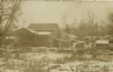
| Date: | 1885 |
|---|---|
| Description: | Elevated view of the Wiscsonsin Central's bridge over the White River, about six miles south of Ashland. The bridge was 1600 ft. long and 110 ft. above the... |

| Date: | 1880 |
|---|---|
| Description: | Man in canoe close to shoreline with a bridge in the background. |

| Date: | 1896 |
|---|---|
| Description: | This 1896 map shows the township and range system, sections, cities and villages, railroads, roads, vacant land and land sold by the Wisconsin Central Rail... |

| Date: | 1896 |
|---|---|
| Description: | This 1898 map shows the township and range system, sections, cities and villages, railroads, roads, vacant land and land sold by the Wisconsin Central Rail... |

| Date: | 1886 |
|---|---|
| Description: | This map shows north and south ore veins, landownership, railroads, rivers, and township grid in parts of Ashland County, Wis. and Ontonagon County, Mich. ... |

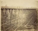
| Date: | 1895 |
|---|---|
| Description: | Stereograph of the side cliff view of the railroad White River bridge, showing the support beams and river underneath. It is six miles south of Ashland. Th... |
If you didn't find the material you searched for, our Library Reference Staff can help.
Call our reference desk at 608-264-6535 or email us at: