 Filter: Categories of Wisconsin Historical Images
Filter: Subject of Rivers
Filter: Year of 1800-1899
Filter: Community of Green Bay
Filter: Categories of Wisconsin Historical Images
Filter: Subject of Rivers
Filter: Year of 1800-1899
Filter: Community of Green Bay

| Date: | 1851 |
|---|---|
| Description: | A rare photograph of U.S. Army soldiers stationed at Fort Howard rowing a boat on the Fox River. Fort Howard, built in 1816, was the first in the chain of ... |

| Date: | 1842 |
|---|---|
| Description: | This hand-colored lithograph of the second Fort Howard, with Indians canoeing on the Fox River, shows the hospital built 1834-1835 outside the stockade on ... |

| Date: | 1867 |
|---|---|
| Description: | Bird's-eye map of Green Bay and Fort Howard, Brown Co., depicts street names and street layouts, houses, trees, and the East River. A reference key at the ... |

| Date: | 1893 |
|---|---|
| Description: | Bird's-eye map of Green Bay and Fort Howard, looking south. Ninety-four locations identified below image; extends to Grignon Street at top left corner, Wi... |

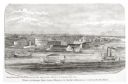
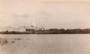
| Date: | 1876 |
|---|---|
| Description: | Elevated view showing Elmore and Kelly's Elevator with a boat, train, and the buildings at Fort Howard. Fort Howard was incorporated into Green Bay. Captio... |

| Date: | 1851 |
|---|---|
| Description: | View of five soldiers rowing in a boat, beside a dock, with another soldier standing on the dock. The fort is in the background, complete with the fortifie... |

| Date: | 1851 |
|---|---|
| Description: | Several men rowing in a boat near Fort Howard that has an American Flag, barracks, and various related military buildings enclosed behind a wall. |
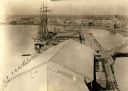
| Date: | 1850 |
|---|---|
| Description: | Elevated view of the Green Bay harbor and docks. |
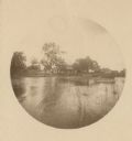
| Date: | 1889 |
|---|---|
| Description: | Distant view of the cottage across the river, with reeds in the foreground. On the original site on the west side of the Fox River, before the restoration. |

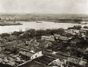
| Date: | 1889 |
|---|---|
| Description: | Elevated view of Fox River and South Washington Street, from the top of St. Willobrord's Church. |

| Date: | 1870 |
|---|---|
| Description: | Five piece panoramic view of the Green Bay waterfront area. |
| Date: | 1889 |
|---|---|
| Description: | Elevated view of Washington Street and the Fox River and buildings nearby. |
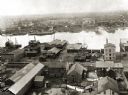
| Date: | 1876 |
|---|---|
| Description: | View looking southeast over river from Elmore and Kelly's Elevator. |
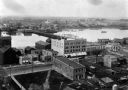
| Date: | 1889 |
|---|---|
| Description: | View of Green Bay from the Fort Howard side of the Fox River. |
| Date: | 1889 |
|---|---|
| Description: | View of Green Bay from the top of St. Willibrord's Church. A river can be seen in the background. |
| Date: | 1889 |
|---|---|
| Description: | Southwest view of the Fox River and the waterfront. |
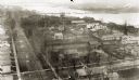
| Date: | 1889 |
|---|---|
| Description: | Elevated view of an industrial waterfront along the Fox River. |

| Date: | 1889 |
|---|---|
| Description: | View of the Fox River between Green Bay and Fort Howard. |

| Date: | 1821 |
|---|---|
| Description: | Plan of the settlement of Green Bay. |

| Date: | 1835 |
|---|---|
| Description: | Ink on tracing paper map of Green Bay, Wisconsin and nearby areas, Lake Winnebago, Fox and Wolf Rivers, and the junctions of the Mississippi and Wisconsin ... |
If you didn't find the material you searched for, our Library Reference Staff can help.
Call our reference desk at 608-264-6535 or email us at: