 Filter: Categories of Wisconsin Historical Images
Filter: Subject of Rivers
Filter: Subject of transportation
Filter: Reproduction Rights of Special Conditions
Filter: Categories of Wisconsin Historical Images
Filter: Subject of Rivers
Filter: Subject of transportation
Filter: Reproduction Rights of Special Conditions

| Date: | 1883 |
|---|---|
| Description: | Bird's-eye map of Manitowoc. |

| Date: | 1688 |
|---|---|
| Description: | This map includes vignettes of Amerindian life with text describing geography, culture, and exploration activity, written in French. The Great Lakes, river... |

| Date: | 1755 |
|---|---|
| Description: | Hand-colored. Paris: 1755. Scale [ca. 1:3,000,000]. |
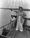
| Date: | 1942 |
|---|---|
| Description: | Olive Brooks, Army Division Engineer Public Relations with her .45 on the "Dolphin", Chucunaque River, Panama. She is pointing her gun out towards the rive... |

| Date: | 2013 |
|---|---|
| Description: | Map is the most extensive endeavor to date to accurately locate and document both prehistoric place names and natural features of the Menominee language wi... |
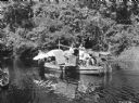
| Date: | 1951 |
|---|---|
| Description: | Cast and crew of the 1951 film "The African Queen" on a boat, preparing to film a scene. They are floating on a body of water, with trees behind them. Acto... |
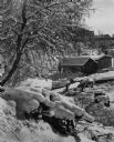
| Date: | 1950 |
|---|---|
| Description: | A boathouse, boat and pier on the frozen shoreline of the Mississippi River. More buildings appear in the background, a snow covered tree on the left and a... |
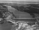
| Date: | 1950 |
|---|---|
| Description: | Aerial view of a hydroelectric power plant owned by Northern States Power Company located on the Chippewa River. A highway bridge and a railroad bridge spa... |
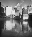
| Date: | 1955 |
|---|---|
| Description: | Industries along the Milwaukee River, one of which is the Schlitz Brewery. |
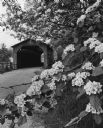
| Date: | 06 1969 |
|---|---|
| Description: | The Cedarburg Bridge, originally known as the Red Bridge, with a flowering tree on the right. Originally Wisconsin had more than 40 covered bridges. This i... |
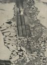
| Date: | 12 1976 |
|---|---|
| Description: | Towboat pushing barges through ice on the Mississippi River as winter closes shipping traffic. Elevated view shows broken ice surrounding the barges, creat... |

| Date: | 1963 |
|---|---|
| Description: | Elevated view from East College Avenue bridge of motor boats exiting Lock #4 on the Upper Fox River. |
If you didn't find the material you searched for, our Library Reference Staff can help.
Call our reference desk at 608-264-6535 or email us at: