Filter: Categories of Wisconsin Historical Images
Filter: Subject of Rivers
Filter: Subject of transportation
Filter: County of Marinette
Filter: Categories of Wisconsin Historical Images
Filter: Subject of Rivers
Filter: Subject of transportation
Filter: County of Marinette

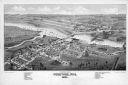
| Date: | 09 1871 |
|---|---|
| Description: | Bird's-eye view of Peshtigo, before it was destroyed by fire on the night of October 8, 1871. |

| Date: | 1881 |
|---|---|
| Description: | Bird's-eye map of Marinette, with insets. |
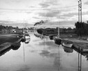
| Date: | 1945 |
|---|---|
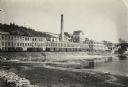
| Description: | Harbor in Marinette at sunset. Boats are docked at the sides of a canal. Smoke pours from smokestacks of a facility in the distance. |
| Date: | 1963 |
|---|---|
| Description: | H.P. Christ Feed Mill. The first building across the street is the Atlas Hotel which was located at the site of the present Milo Howarth senior home. Other... |

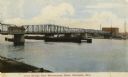
| Date: | 1905 |
|---|---|
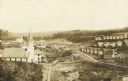
| Description: | View from shoreline toward the new Hattie Street Bridge. Factory buildings are on the shoreline behind. Caption reads: "New Hattie Street Bridge, Marinette... |
| Date: | 1908 |
|---|---|
| Description: | View from dock toward the drawbridge. Caption reads: "Drawbridge from Menekaunee Dock, Marinette, Wis." |
| Date: | |
|---|---|
| Description: | The Menominee River and paper mill as photographed by William A. Hotchkiss for the Wisconsin Good Roads Association. |
| Date: | 1910 |
|---|---|
| Description: | An elevated view of town. A church is on the left, houses are in rows on the right. Caption reads: "Made-For-Club-House — Niagara-Wis.—". |

| Date: | |
|---|---|
| Description: | Colorized view across a river toward Dunlap Square. A bridge is on the right. Caption reads: "Dunlap Square, Marinette, Wis." |

| Date: | |
|---|---|
| Description: | Colorized view of a road along a river. Caption reads: "The River Road, Marinette, Wis." |
| Date: | |
|---|---|
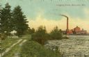
| Description: | Colorized view of a river full of logs, and a smokestack and factory in the distance. On the left is a dirt road and trees. Caption reads: "Logging Scene, ... |
| Date: | |
|---|---|
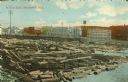
| Description: | Colorized view of a log jam scene with industrial buildings in the background. Caption reads: "A Log Jam, Marinette, Wis." |

| Date: | |
|---|---|
| Description: | A bird's-eye view of Marinette looking southwest from the Menominee side of the river. |
| Date: | |
|---|---|
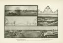
| Description: | A composite of three photographs of the Menominee River with decorative graphics. Views of the river include log drivers and an elevated perspective of the... |
| Date: | 1887 |
|---|---|
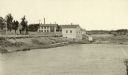
| Description: | View of the boom company office and the site of the old trading post. |

| Date: | 1941 |
|---|---|
| Description: | A tourist map of Marinette County, Wisconsin that includes indexes of the lakes and rivers in the county which also identify the fish present, a list of ra... |

| Date: | 1951 |
|---|---|
| Description: | Water depths shown by bathymetric tints and soundings. Relief shown by contours. "Depths in feet." "Aids to navigation corrected to May 4, 1951." On verso:... |

| Date: | |
|---|---|
| Description: | Aerial view of harbor. In the foreground is a lighthouse and breakwaters. Bridges cross the harbor, and there are factory and industrial buildings near the... |

| Date: | 1912 |
|---|---|
| Description: | This blueprint manuscript map shows selected buildings, roads, and the Peshtigo River. |
If you didn't find the material you searched for, our Library Reference Staff can help.
Call our reference desk at 608-264-6535 or email us at: