 Filter: Categories of Wisconsin Historical Images
Filter: Subject of Rivers
Filter: Subject of transportation
Filter: County of Dunn
Filter: Categories of Wisconsin Historical Images
Filter: Subject of Rivers
Filter: Subject of transportation
Filter: County of Dunn
| Date: | 1910 |
|---|---|
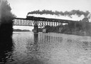
| Description: | The railroad trestle over the Red Cedar River with a steam train passing over. |
| Date: | 1880 |
|---|---|
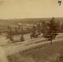
| Description: | The view of Red Cedar River from Meadow Hill. |
| Date: | 1899 |
|---|---|
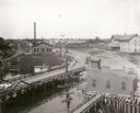
| Description: | Elevated view looking north towards Menomonie, the Knapp, Stout and Company lumber mills. |

| Date: | 1910 |
|---|---|
| Description: | Elevated view across rooftops towards the dam on the Red Cedar River, also showing the electric power plant and mills. Caption reads: "Lake and Falls, Meno... |

| Date: | 1908 |
|---|---|
| Description: | Elevated view of the dam on the Red Cedar River, also showing the electric power plant and mills. Caption reads: "Bridge, Falls, Electric Power House and t... |
| Date: | 1895 |
|---|---|
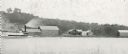
| Description: | Rumsey's Landing on the Chippewa River about two miles below Caryville. |

| Date: | |
|---|---|
| Description: | A wooden footbridge crosses Wilson Creek in a wooded area. |

| Date: | |
|---|---|
| Description: | A man rows a boat along a sandy bank in Wilson Creek. The water is surrounded by a forested area. |

| Date: | |
|---|---|
| Description: | A group of youth sits on a shoreline along the Red Cedar River while others swim and boat. A stone structure stands in the center of the river and foreste... |

| Date: | |
|---|---|
| Description: | A railroad bridge crosses over Red Cedar River. |

| Date: | |
|---|---|
| Description: | View of an arch bridge over the Red Cedar River. Forested shorelines surround the water. |

| Date: | |
|---|---|
| Description: | A creek runs beneath the stone underpass of Clove Bridge. Trees, logs, and foliage surrounding the structure. |

| Date: | |
|---|---|
| Description: | A river passes beneath a truss bridge. City buildings are visible on the opposite side of the structure. |

| Date: | 1855 |
|---|---|
| Description: | Map reads: "Knapp, Stout & Co., William Carson, Henry Eaton, Amos Collum, William Wilson & C.S. Bundy Proprietors."Streets running horizontally begin at th... |

| Date: | 1890 |
|---|---|
| Description: | Shows plat of town, local streets, steam boat landings, and Chippewa River. Public square and Muskoo Island hand-colored. Map reads: "Full Lots are 125x66 ... |
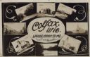
| Date: | 11 16 1908 |
|---|---|
| Description: | Photographic COLLAGE postcard of scenes of Colfax. In the center oval is the text, "Colfax, Wis. Looks Good To Me," however the "Looks Good To Me" is cross... |
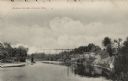
| Date: | 1914 |
|---|---|
| Description: | Black and white photographic postcard looking up river towards the Wagon Bridge. Caption reads: "Wagon Bridge, Colfax, Wis." |

| Date: | 1875 |
|---|---|
| Description: | This plat map shows local streets, buildings, numbered blocks and lots, part of the Red Cedar River, and land ownership by name. Also included is a busines... |

| Date: | 1896 |
|---|---|
| Description: | This map shows plat of town, local streets, numbered blocks and lots, mill pond, mills, part of the Red Cedar River, and land and property ownership by nam... |

| Date: | 1911 |
|---|---|
| Description: | This map shows plat of town, local streets, numbered lots, blocks, and wards, roads, Lake Menomin, Wilson Creek, Red Cedar River, and land ownership by nam... |
If you didn't find the material you searched for, our Library Reference Staff can help.
Call our reference desk at 608-264-6535 or email us at: