 Filter: Categories of Wisconsin Historical Images
Filter: Subject of Rivers
Filter: Subject of transportation
Filter: County of Ashland
Filter: Categories of Wisconsin Historical Images
Filter: Subject of Rivers
Filter: Subject of transportation
Filter: County of Ashland
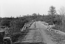
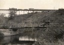
| Date: | 06 01 1936 |
|---|---|
| Description: | Bridge and truck trail constructed by Works Progress Administration (WPA) workmen to facilitate forest fire prevention and control. |
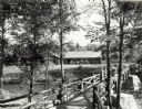
| Date: | 1940 |
|---|---|
| Description: | People on a rustic bridge over river at Copper Falls State Park. A long log building is in the background on the other side of the river. |
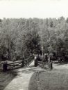
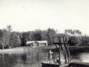
| Date: | |
|---|---|
| Description: | Two people on a rustic bridge over Bad River at Copper Falls State Park. |
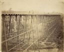
| Date: | 1885 |
|---|---|
| Description: | Elevated view of the Wiscsonsin Central's bridge over the White River, about six miles south of Ashland. The bridge was 1600 ft. long and 110 ft. above the... |
| Date: | 1910 |
|---|---|
| Description: | View from shoreline of a railroad train crossing a bridge over the famous White River near Ashland. In the foreground is an open automobile crossing the ri... |
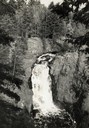
| Date: | 1935 |
|---|---|
| Description: | Elevated view of the Brownstone Falls on the Bad River. |

| Date: | 1880 |
|---|---|
| Description: | Man in canoe close to shoreline with a bridge in the background. |

| Date: | 1900 |
|---|---|
| Description: | Wisconsin Central train passing over the White River bridge. The first railroad car is imprinted with "U.S. Mail." |
| Date: | 07 1940 |
|---|---|
| Description: | The bathing beach and bath house at Copper Falls State Park. Two swimmers are sitting and standing on a dock with a platform. |
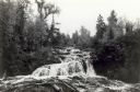
| Date: | 09 1937 |
|---|---|
| Description: | View upriver of the rapids above Tyler Falls at Copper Falls State Park. In the distance you can see a bridge across the river. |

| Date: | 07 1940 |
|---|---|
| Description: | Two boys and two girls swimming at the Bad River at Copper Falls State Park. One of the girls is diving off the dock that also has a platform. In the backg... |

| Date: | 1939 |
|---|---|
| Description: | This map shows the towns to Gingles, Sanborn, and Guney as well as Chequamegon Bay, Kakagon River, White River, Marengo River, Bad River, Potato River, Vau... |

| Date: | 1952 |
|---|---|
| Description: | This 1952 map shows the trails, roads, and railroads through the counties of Ashland, Bayfield, Sawyer, Price, Iron, and Vilas. Also shown are lakes, river... |

| Date: | 1896 |
|---|---|
| Description: | This 1896 map shows the township and range system, sections, cities and villages, railroads, roads, vacant land and land sold by the Wisconsin Central Rail... |

| Date: | 1896 |
|---|---|
| Description: | This 1898 map shows the township and range system, sections, cities and villages, railroads, roads, vacant land and land sold by the Wisconsin Central Rail... |
| Date: | 1935 |
|---|---|
| Description: | View from shoreline of men fishing out of wooden rowboats on the Flambeau River below the flowage dam. One man is standing in the river. A shack is visible... |
If you didn't find the material you searched for, our Library Reference Staff can help.
Call our reference desk at 608-264-6535 or email us at:


