 Filter: Categories of Wisconsin Historical Images
Filter: Subject of Rivers
Filter: Subject of railroad stations
Filter: Categories of Wisconsin Historical Images
Filter: Subject of Rivers
Filter: Subject of railroad stations

| Date: | 1868 |
|---|---|
| Description: | This 1868 birds-eye view depicts the buildings, streets, railroad, vegetation and topography of Columbus, Wisconsin. The high school, cemetery, railroad de... |

| Date: | 1915 |
|---|---|
| Description: | Elevated view of the St. Croix River, Northwest Railroad, bridge, and part of the town of Hudson. Caption reads: "Hudson, Wis. Bird's Eye View, showing St.... |
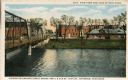
| Date: | 1905 |
|---|---|
| Description: | View with the Milwaukee Street Bridge on the left, and on the opposite shoreline is the Chicago & Northwestern Railway Station. Caption at top reads: "View... |

| Date: | |
|---|---|
| Description: | 1. Stone Astor Fur Co. building built in 1808. 2. Voth Cottage, built in 1930. 3. Brisbois mansion, built 1808, by Michael Brisbois. 4. Site of Hudson Bay ... |

| Date: | 1863 |
|---|---|
| Description: | A map of Illinois showing all railroads, stations, and towns. |

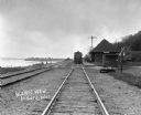
| Date: | 1870 |
|---|---|
| Description: | View across water toward the back side of a railroad station and outbuilding that face the creek. A hotel, garage, and homes are around the structure. |
| Date: | |
|---|---|
| Description: | Locomotive at the De Soto depot on the Chicago, Burlington and Quincy Railroad line. The Mississippi River is on the left. |

| Date: | 1866 |
|---|---|
| Description: | This map shows the railroads both completed and under construction in southern Wisconsin, Iowa, Illinois, and Missouri. Railroad terminals, junctions, and ... |

| Date: | 1867 |
|---|---|
| Description: | This map, which includes eastern Iowa, northern Illinois and the western portion of Michigan's Upper peninsula, shows the township survey grid and identifi... |
| Date: | 09 1996 |
|---|---|
| Description: | "This is Theresa Station. Note the Rock River and Soo Line Railroad track." |

| Date: | 1886 |
|---|---|
| Description: | A hand-colored map of Milwaukee County, Wisconsin that shows the township and range system, sections, towns, roads, railroads and rail stations, cities and... |

| Date: | 1891 |
|---|---|
| Description: | A hand-colored map of Milwaukee County, Wisconsin that shows the township and range system, sections, towns, roads, railroads and rail stations, cities and... |

| Date: | 1902 |
|---|---|
| Description: | A map of Milwaukee County, Wisconsin that shows the township and range system, sections, towns, roads, railroads and rail stations, cities and villages, po... |

| Date: | 1898 |
|---|---|
| Description: | Map showing the contour depths of the lakes in northwestern Waukesha County, Wisconsin. Roads, railroads, depots, churches, schools, and hotels in the area... |

| Date: | 1891 |
|---|---|
| Description: | This maps has an index of depots, hotels, prominent institutions and buildings, churches, and places of amusement. The map was removed from an unidentified... |

| Date: | 1800 |
|---|---|
| Description: | Shows plat of town, land ownership by name, local streets, courthouses, churches, hotels, mills, railroads, railroad stations, lakes, and rivers. Includes ... |

| Date: | 1903 |
|---|---|
| Description: | Map shows railroads, roads, street car lines, schools, churches, cemeteries, town halls, and railroad stations. Includes inset lists of: Population of Milw... |
| Date: | |
|---|---|
| Description: | The arrangements Somebody takes care of it: planning the details, announcements, transportation, setting the tone, fitting all the likel... |
| Date: | |
|---|---|
| Description: | Every macho-mind knows exactly what and where it is — up front, smoking hot, born to circumstance, savage watchman of the several thousand Rights |
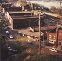
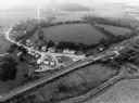
| Date: | 1968 |
|---|---|
| Description: | Elevated view looking down over the railroad station district. |
If you didn't find the material you searched for, our Library Reference Staff can help.
Call our reference desk at 608-264-6535 or email us at: