 Filter: Categories of Wisconsin Historical Images
Filter: Subject of Rivers
Filter: Subject of maintenance and repair
Filter: Categories of Wisconsin Historical Images
Filter: Subject of Rivers
Filter: Subject of maintenance and repair
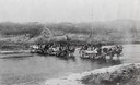
| Date: | 1880 |
|---|---|
| Description: | Crossing a river on the way to Vermillion Lake in the early 1880's, before the building of any railroads in that part of the country. The teams were part o... |

| Date: | 01 1940 |
|---|---|
| Description: | Map shows roads, railroads, the Fox River, parks, schools, and cemeteries and is indexed by street name in the margins. The bottom of the map show the Winn... |

| Date: | 1932 |
|---|---|
| Description: | This map shows automobile routes across Wisconsin and parts of Illinois, Michigan, Minnesota and Iowa. The Mississippi River, Lake Michigan, Lake Superior,... |
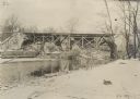
| Date: | |
|---|---|
| Description: | The destroyed bridge in the park at Skiernewize (Skierniewice), which has been replaced by the Germans with a first-rate emergency bridge. |
If you didn't find the material you searched for, our Library Reference Staff can help.
Call our reference desk at 608-264-6535 or email us at: