Filter: Categories of Wisconsin Historical Images
Filter: Subject of Rivers
Filter: Subject of human settlements
Filter: Categories of Wisconsin Historical Images
Filter: Subject of Rivers
Filter: Subject of human settlements

| Date: | 1890 |
|---|---|
| Description: | Portion of the plat map of the north part of Caledonia in Columbia County, including explanations. |

| Date: | 1890 |
|---|---|
| Description: | Plat map of the south part of Caledonia in Columbia County. |
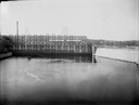
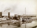
| Date: | 1945 |
|---|---|
| Description: | Harbor in Marinette at sunset. Boats are docked at the sides of a canal. Smoke pours from smokestacks of a facility in the distance. |
| Date: | |
|---|---|
| Description: | Elevated view of Milwaukee River from Walker's Point Bridge. |
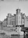
| Date: | |
|---|---|
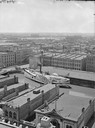
| Description: | View across water towards Best's South Side Brewery. There are railroad cars in front of the brewery. |
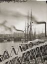
| Date: | |
|---|---|
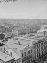
| Description: | Milwaukee, south from Mitchell Block. View shows rooftops and building fronts. Ships and bridge are in the background on the right. |
| Date: | |
|---|---|
| Description: | Elevated view of Milwaukee, looking southwest from Mitchell block showing buildings, and the paddle steamer John A. Dix. |
| Date: | |
|---|---|
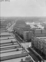
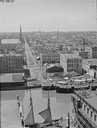
| Description: | Milwaukee, northwest from Mitchell block. Elevated view of rooftops and buildings with River in background. |
| Date: | |
|---|---|
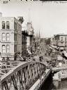
| Description: | Elevated view of Grand Avenue and a bridge over the river, with streetcar and horse-drawn vehicles on the street. |
| Date: | |
|---|---|
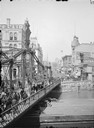
| Description: | Elevated view over bridge and river looking up Grand Avenue. Pedestrians, horse-drawn vehicles and a street car are in the foreground. |
| Date: | |
|---|---|
| Description: | Elevated view west from Mitchell Block of warehouses, industrial buildings and a church in the background. In the foreground is a waterway with a schooner ... |
| Date: | |
|---|---|
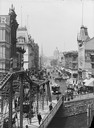
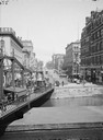
| Description: | View up Grand Avenue from bridge. Pedestrians and horse-drawn vehicles cross bridge on the left. |
| Date: | |
|---|---|
| Description: | View up Wisconsin Avenue towards a bridge with pedestrian and horse-drawn vehicle traffic. Buildings along a street are in the distance. |
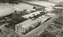
| Date: | 1931 |
|---|---|
| Description: | Aerial view of International Harvester's Rock Falls Works. The factory was owned by the Keystone Manufacturing Company until 1904, when the company was pur... |
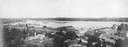
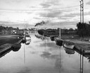
| Date: | 1910 |
|---|---|
| Description: | Menomonie at the turn of the century, view of the river and town. |
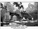
| Date: | 1867 |
|---|---|
| Description: | Engraving of the McCormick Reaper Works as it appeared in 1867. The factory was located on the north bank of the Chicago River, east of the Rush Street bri... |
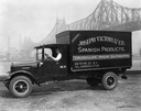
| Date: | 07 05 1927 |
|---|---|
| Description: | Driver in an International delivery truck parked along the waterfront with the Queensboro Bridge in the background. The truck was owned by Joseph Victori &... |
| Date: | 1900 |
|---|---|
| Description: | View across water towards a boat called "The Imperial" moored along the dock at the McCormick Reaper Works. The boat is loaded with freight. In the backgro... |
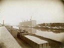
| Date: | 1900 |
|---|---|
| Description: | McCormick Reaper Works and wood shop stock yard as seen from across a canal. In the foreground is a rail yard with a small engine and rail cars. The factor... |
If you didn't find the material you searched for, our Library Reference Staff can help.
Call our reference desk at 608-264-6535 or email us at: