 Filter: Categories of Wisconsin Historical Images
Filter: Subject of Rivers
Filter: Subject of human settlements
Filter: Subject of land
Filter: Categories of Wisconsin Historical Images
Filter: Subject of Rivers
Filter: Subject of human settlements
Filter: Subject of land
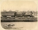
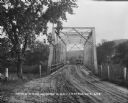
| Date: | 1884 |
|---|---|
| Description: | View across water of a Milwaukee, Lake Shore, and Western Railroad locomotive (No #33) pulling a pay car across a trestle over the Fox River. Several large... |
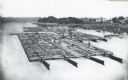
| Date: | 1870 |
|---|---|
| Description: | Elevated view of lumber raft and workers on the Chippewa River. In the background on the right are dwellings. |
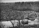
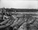
| Date: | 1869 |
|---|---|
| Description: | Elevated view from steep shoreline of a log jam of about 150 million feet of logs, stopped at the piers of Pound, Halbert, and Co., which stood in about 40... |

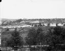
| Date: | 09 1871 |
|---|---|
| Description: | Bird's-eye view of Peshtigo, before it was destroyed by fire on the night of October 8, 1871. |

| Date: | 1881 |
|---|---|
| Description: | Bird's-eye map of Marinette, with insets. |

| Date: | 1905 |
|---|---|
| Description: | Elevated view of Soldiers' Grove with a bridge in the foreground. |
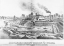
| Date: | 1880 |
|---|---|
| Description: | Lithograph of the Milwaukee Cement Company's Works at 154 West Water Street in Milwaukee. |
| Date: | |
|---|---|
| Description: | View down a metal bridge over the Kickapoo River showing a truck parked on the far side of the bridge. A man and a boy are standing at the rail of the brid... |

| Date: | 1850 |
|---|---|
| Description: | Painting depicting Chippewa Falls and the first sawmill on the Chippewa River, built by Jean Brunet. The residence of H.S. Allen, one of the owners of the... |
| Date: | |
|---|---|
| Description: | Elevated view from south side of the Chippewa River, with a bridge crossing it and buildings on both sides of the river. A bluff rises on the far side of t... |
| Date: | 1903 |
|---|---|
| Description: | Three barefoot boys stand on a pile of logs in the foreground looking across the river at a group of men working to free a log jam in the Big Eddy on the C... |

| Date: | 1873 |
|---|---|
| Description: | Map of the township of Windsor, from the "Atlas of Dane County." |

| Date: | 1848 |
|---|---|
| Description: | In 1849, northern Wisconsin was composed of huge sectional regions such as Chippewa, Portage, Brown and Crawford, whereas southern Wisconsin was constitute... |

| Date: | 1861 |
|---|---|
| Description: | Drawn the first year of the Civil War, this colored 1861 map of Dane County shows its towns, cities and lakes. It includes insets of the wards of Madison a... |
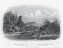
| Date: | 1832 |
|---|---|
| Description: | Engraving of Indians on horseback along river with Indian grave on hill in background. |

| Date: | |
|---|---|
| Description: | Map of the district of the Peshtigo fire, approximately 1,280,000 acres, in Wisconsin and Upper Michigan. |

| Date: | 1890 |
|---|---|
| Description: | Portion of the plat map of the north part of Caledonia in Columbia County, including explanations. |

| Date: | 1890 |
|---|---|
| Description: | Plat map of the south part of Caledonia in Columbia County. |

| Date: | 1876 |
|---|---|
| Description: | Bird's-eye view of Black Earth. |
If you didn't find the material you searched for, our Library Reference Staff can help.
Call our reference desk at 608-264-6535 or email us at:
