Filter: Categories of Wisconsin Historical Images
Filter: Subject of Rivers
Filter: Subject of human settlements
Filter: County of Waupaca
Filter: Categories of Wisconsin Historical Images
Filter: Subject of Rivers
Filter: Subject of human settlements
Filter: County of Waupaca

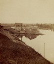
| Date: | 1871 |
|---|---|
| Description: | Birds eye map of New London depicts street names and street locations, houses, trees, the bridge, Wolf River, and the bayou. At the bottom of the map, a re... |

| Date: | 1965 |
|---|---|
| Description: | Aerial view of downtown Big Falls and the Little Wolf River. The Little Wolf River is at lower right. |

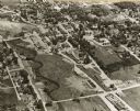
| Date: | 1910 |
|---|---|
| Description: | Aerial view of some of the 26 lakes known collectively as the Chain O' Lakes. Caption reads: "Aeroplane View of Chain O'Lakes, Waupaca, Wis." |
| Date: | 11 16 1989 |
|---|---|
| Description: | View from the Water Street Bridge over the Waupaca River toward the Waupaca Water Department. |

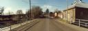
| Date: | 11 16 1989 |
|---|---|
| Description: | Water Street Bridge over the Waupaca River in the city of Waupaca. |
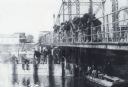
| Date: | 1870 |
|---|---|
| Description: | A large group of men are snagging sturgeon from a bridge over the Wolf River. A sturgeon is hanging from a line. More men are sitting on a bridge support, ... |
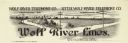
| Date: | |
|---|---|
| Description: | Letterhead of Wolf River Lines, a telephone company in Weyauwega, Wisconsin, with telephone poles and wires spanning a river with silhouettes of buildings ... |
| Date: | 1930 |
|---|---|
| Description: | View of new bridge over a river, and on the other side the Folkman's store. Caption reads: "New Bridge & Folkman's Store, Clintonville, Wis." |
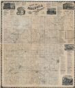
| Date: | 1874 |
|---|---|
| Description: | This map shows townships and sections, land ownership and acreages, churches, schools, cemeteries, roads, railroads, and projected railroads. The map inclu... |

| Date: | 1901 |
|---|---|
| Description: | This map shows landownership and acreages, townships and sections, and selected buildings. |
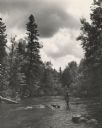
| Date: | 1950 |
|---|---|
| Description: | View across water towards a man fly fishing while standing in the river. He is wearing waders and a hat, and a creel and a net are hanging at his sides. He... |
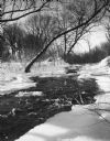
| Date: | 1964 |
|---|---|
| Description: | The Crystal River running between icy banks lined with trees. |
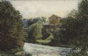
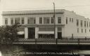
| Date: | 1907 |
|---|---|
| Description: | Text on front reads: "Old Parfreyville Mill on Crystal River. Waupaca, Wis." A wooden mill on the banks of a river with a grass and tree covered shoreline. |

| Date: | 01 12 1910 |
|---|---|
| Description: | Text on front reads: "Fall Mill St., Waupaca, Wis." Water flowing over a dam on the Waupaca River. There are advertising signs on the dam and buildings ca... |
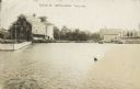
| Date: | 1910 |
|---|---|
| Description: | Text on front reads: "Scene at Weyauwega, Wis." View across water towards the Weyauwega Mills and grain elevator on the left, with a horse-drawn wagon on t... |
If you didn't find the material you searched for, our Library Reference Staff can help.
Call our reference desk at 608-264-6535 or email us at: