 Filter: Categories of Wisconsin Historical Images
Filter: Subject of Rivers
Filter: Subject of human settlements
Filter: County of Walworth
Filter: Categories of Wisconsin Historical Images
Filter: Subject of Rivers
Filter: Subject of human settlements
Filter: County of Walworth

| Date: | 1884 |
|---|---|
| Description: | Bird's-eye map of Delavan with inset of the State Institute for Deaf and Dumb. |

| Date: | 1870 |
|---|---|
| Description: | Bird's-eye view of Whitewater, with insets. |
| Date: | 1910 |
|---|---|
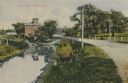
| Description: | Distant view of the mill, with a stream leading to it, and a road paralleling the stream on the right. Caption reads: "The Old Mill, Delavan, Wis." |
| Date: | 1905 |
|---|---|
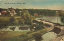
| Description: | Elevated view of a pond, a stream, and a lake, with a road dividing the pond and stream from the lake. Industrial buildings and a smokestack are in the bac... |

| Date: | 1907 |
|---|---|
| Description: | Elevated view over water towards Main Street with bridge. Caption reads: "Main St. in 1907, Whitewater, Wis." |

| Date: | 1916 |
|---|---|
| Description: | Southeastern Wisconsin which lies east of Whitewater and south of Port Washington. |

| Date: | 1907 |
|---|---|
| Description: | Shows post offices, railroads, country clubs, and land ownership by name. |
| Date: | |
|---|---|
| Description: | View of the road bridge over Honey Creek leading to Honey Creek. Caption reads: "'The Bridge' Honey Creek, Wis." |

| Date: | 1912 |
|---|---|
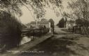
| Description: | Text on front reads: "The Old Swimming Hole, Whitewater, Wis." A swimming area in a river, with a bridge in the background, surrounded by trees. |
If you didn't find the material you searched for, our Library Reference Staff can help.
Call our reference desk at 608-264-6535 or email us at: