Filter: Categories of Wisconsin Historical Images
Filter: Subject of Rivers
Filter: Subject of cities and towns
Filter: County of Pierce
Filter: Categories of Wisconsin Historical Images
Filter: Subject of Rivers
Filter: Subject of cities and towns
Filter: County of Pierce
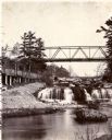
| Date: | 1885 |
|---|---|
| Description: | View looking up river towards the Kinnickinnic Falls. A bridge is above the falls. |

| Date: | 1870 |
|---|---|
| Description: | Half stereograph of an elevated view from hill showing the confluence of the Mississippi River and the St. Croix River. A man wearing a hat is in the foreg... |
| Date: | 1886 |
|---|---|
| Description: | View of the Chicago, Burlington, and Quincy railroad drawbridge and trestle. |

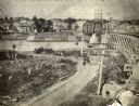
| Date: | 1884 |
|---|---|
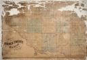
| Description: | Page one of a Sanborn map of River Falls, Wisconsin. |

| Date: | 1910 |
|---|---|
| Description: | Text on front reads: "Power-House and Pumping Station. River Falls, Wis." A hydroelectric station on the Kinnickinnic River. Today there are two dams and p... |
If you didn't find the material you searched for, our Library Reference Staff can help.
Call our reference desk at 608-264-6535 or email us at: